Wola Rakowa geodata
Wola Rakowa (Łódź Voivodeship) is a populated place; located in Poland in Europe/Warsaw (GMT+2) time zone. With population of 590 people, there are 3306 cities with bigger population in this country. Compared to other cities in Poland, 59.7% of cities are located further ↓South; 50.9% of cities are located further ←West and 64.8% of cities have lower elevation than Wola Rakowa. Note1
Administrative division(s):
- Level 1: Łódź Voivodeship
- Level 2: Powiat łódzki wschodni
- Level 3: Brójce


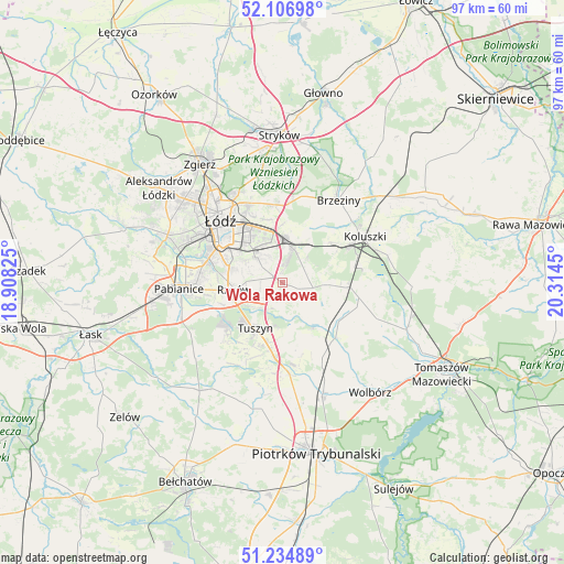
Wola Rakowa GPS coordinates[2]
51° 40' 22.908" North, 19° 36' 40.932" East
| Map corner | latitude | longitude |
|---|---|---|
| Upper-left | 52.10698°, | 18.90825° |
| Center: | 51.67303°, | 19.61137° |
| Lower-right: | 51.23489°, | 20.3145° |
| Map W x H: | 97×97 km | = 60.3×60.3mi |
| max Lat: | 54.83135° ⇑40.3% North |
| Wola Rakowa: | 51.67303° |
| min Lat: | ⇓59.7% South 49.21328° |
| min Long | Wola Rakowa | max Long |
| 14.20249° | 19.61137° | 24.03723° |
| W 50.9%⇐ | ⇒49.1% E |
Elevation
Elevation of Wola Rakowa is 214 m = 702 ft, and this is 22.6 m = 74 ft above average elevation for this country.
| Max E: |
974 m = 3196 ft | 35.2% |
| Wola Rakowa | 214 m 702 ft | |
| Avg. | 191.4 m = 628 ft | |
Min E: |
-3 m = -10 ft | 64.8% |
See also: Poland elevation on elevation.city.
Geographical zone
Wola Rakowa is located in North temperate zone (between Tropic of Cancer and the Arctic Circle). Distance of this North polar circle is 1655.7 km =1028.8 mi to North.| Distance of | km | miles | from Wola Rakowa |
|---|---|---|---|
| North Pole | 4261.6 | 2648 | to North |
| Arctic Circle | 1655.7 | 1028.8 | to North |
| Tropic Cancer | 3139.6 | 1950.9 | to South |
| Equator | 5745.5 | 3570.1 | to South |


Nearby cities:
15 places around Wola Rakowa: (largest is in red/bold)
• Andrespol
6.4 km =4 mi,  18°
18°
• Brzeziny
17.1 km =10.6 mi,  34°
34°
• Brójce
2.7 km =1.7 mi,  110°
110°
• Będków
13.5 km =8.4 mi,  134°
134°
• Czarnocin
10.3 km =6.4 mi,  151°
151°
• Gałków Duży
10.5 km =6.5 mi,  48°
48°
• Gałków Mały
9.1 km =5.7 mi, 50°
• Koluszki
16.1 km =10 mi,  63°
63°
• Ksawerów
14.4 km =8.9 mi,  274°
274°
• Rokiciny
13.4 km =8.3 mi,  100°
100°
• Rokiciny-Kolonia
11.9 km =7.4 mi,  94°
94°
• Rzgów
8.3 km =5.2 mi,  262°
262°
• Starowa Góra
9 km =5.6 mi,  283°
283°
• Tuszyn
9 km =5.6 mi,  218°
218°
• Łódź
14.4 km =8.9 mi,  318°
318°
Sources, notices
• [Note1] Compared only with cities in Poland existing in our database
• [Src1] Map data: © OpenStreetMap contributors (CC-BY-SA)
• [Src2] Other city data from geonames.org with taken over terms of usage.
• [Src3] Geographical zone / Annual Mean Temperature by Robert A. Rohde @ Wikipedia
