Zelów geodata
Zelów (Łódź Voivodeship) is a seat of a third-order administrative division; located in Poland in Europe/Warsaw (GMT+2) time zone. With population of 8,003 people, there are 509 cities with bigger population in this country. Compared to other cities in Poland, 55.7% of cities are located further ↓South; 55.6% of cities are located further →East and 56.5% of cities have lower elevation than Zelów. Note1


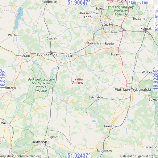
Zelów GPS coordinates[2]
51° 27' 52.272" North, 19° 13' 10.992" East
| Map corner | latitude | longitude |
|---|---|---|
| Upper-left | 51.90047°, | 18.5166° |
| Center: | 51.46452°, | 19.21972° |
| Lower-right: | 51.02437°, | 19.92285° |
| Map W x H: | 97.4×97.4 km | = 60.5×60.5mi |
| max Lat: | 54.83135° ⇑44.3% North |
| Zelów: | 51.46452° |
| min Lat: | ⇓55.7% South 49.21328° |
| min Long | Zelów | max Long |
| 14.20249° | 19.21972° | 24.03723° |
| W 44.4%⇐ | ⇒55.6% E |
Elevation
Elevation of Zelów is 189 m = 620 ft, and this is 2.4 m = 8 ft below average elevation for this country.
| Max E: |
974 m = 3196 ft | 43.5% |
| Avg. | 191.4 m = 628 ft | |
| Zelów | 189 m = 620 ft | |
Min E: |
-3 m = -10 ft | 56.5% |
See also: Poland elevation on elevation.city.
Geographical zone
Zelów is located in North temperate zone (between Tropic of Cancer and the Arctic Circle). Distance of this North polar circle is 1678.9 km =1043.2 mi to North.| Distance of | km | miles | from Zelów |
|---|---|---|---|
| North Pole | 4284.7 | 2662.4 | to North |
| Arctic Circle | 1678.9 | 1043.2 | to North |
| Tropic Cancer | 3116.4 | 1936.4 | to South |
| Equator | 5722.3 | 3555.7 | to South |


Nearby cities:
15 places around Zelów: (largest is in red/bold)
• Bełchatów
14.3 km =8.9 mi,  138°
138°
• Buczek
5.7 km =3.5 mi,  317°
317°
• Dobroń
19.5 km =12.1 mi,  5°
5°
• Drużbice
12.1 km =7.5 mi,  90°
90°
• Dłutów
15.9 km =9.9 mi,  48°
48°
• Grabica
21.7 km =13.5 mi, 85°
• Kluki
13.7 km =8.5 mi,  174°
174°
• Pabianice
24.1 km =15 mi,  22°
22°
• Rusiec
22.5 km =14 mi,  226°
226°
• Szczerców
16.5 km =10.3 mi,  207°
207°
• Sędziejowice
14.1 km =8.8 mi,  289°
289°
• Widawa
19.3 km =12 mi,  261°
261°
• Zapolice
24.9 km =15.5 mi, 290°
• Zduńska Wola
24.5 km =15.2 mi,  307°
307°
• Łask
15.3 km =9.5 mi,  336°
336°
Sources, notices
• [Note1] Compared only with cities in Poland existing in our database
• [Src1] Map data: © OpenStreetMap contributors (CC-BY-SA)
• [Src2] Other city data from geonames.org with taken over terms of usage.
• [Src3] Geographical zone / Annual Mean Temperature by Robert A. Rohde @ Wikipedia
