Rusocice geodata
Rusocice (Lesser Poland) is a populated place; located in Poland in Europe/Warsaw (GMT+2) time zone. With population of 1,164 people, there are 2241 cities with bigger population in this country. Compared to other cities in Poland, 82.6% of cities are located further ↑North; 50.9% of cities are located further ←West and 65.3% of cities have lower elevation than Rusocice. Note1


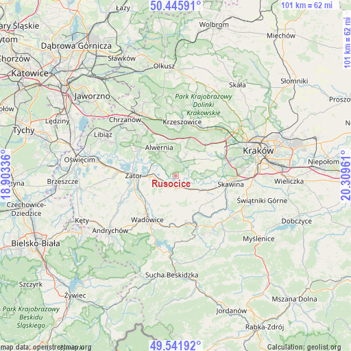
Rusocice GPS coordinates[2]
49° 59' 45.744" North, 19° 36' 23.328" East
| Map corner | latitude | longitude |
|---|---|---|
| Upper-left | 50.44591°, | 18.90336° |
| Center: | 49.99604°, | 19.60648° |
| Lower-right: | 49.54192°, | 20.30961° |
| Map W x H: | 100.5×100.5 km | = 62.4×62.4mi |
| max Lat: | 54.83135° ⇑82.6% North |
| Rusocice: | 49.99604° |
| min Lat: | ⇓17.4% South 49.21328° |
| min Long | Rusocice | max Long |
| 14.20249° | 19.60648° | 24.03723° |
| W 50.9%⇐ | ⇒49.1% E |
Elevation
Elevation of Rusocice is 215 m = 705 ft, and this is 23.6 m = 77 ft above average elevation for this country.
| Max E: |
974 m = 3196 ft | 34.7% |
| Rusocice | 215 m 705 ft | |
| Avg. | 191.4 m = 628 ft | |
Min E: |
-3 m = -10 ft | 65.3% |
See also: Poland elevation on elevation.city.
Geographical zone
Rusocice is located in North temperate zone (between Tropic of Cancer and the Arctic Circle). Distance of this North polar circle is 1842.1 km =1144.6 mi to North.| Distance of | km | miles | from Rusocice |
|---|---|---|---|
| North Pole | 4448 | 2763.9 | to North |
| Arctic Circle | 1842.1 | 1144.6 | to North |
| Tropic Cancer | 2953.1 | 1835 | to South |
| Equator | 5559 | 3454.2 | to South |


Nearby cities:
15 places around Rusocice: (largest is in red/bold)
• Brodła
5.4 km =3.4 mi,  346°
346°
• Brzeźnica
3.6 km =2.2 mi,  164°
164°
• Bęczyn
7.8 km =4.8 mi,  150°
150°
• Czernichów
5.4 km =3.4 mi,  98°
98°
• Kamień
2.3 km =1.4 mi,  319°
319°
• Marcyporęba
5.7 km =3.5 mi,  175°
175°
• Nowa Wieś Szlachecka
7.3 km =4.5 mi,  62°
62°
• Okleśna
6.6 km =4.1 mi,  305°
305°
• Paszkówka
8.2 km =5.1 mi,  141°
141°
• Pozowice
7 km =4.3 mi,  110°
110°
• Przeginia Duchowna
4.3 km =2.7 mi,  50°
50°
• Przeginia Narodowa
4.1 km =2.5 mi,  67°
67°
• Ryczów
4.4 km =2.7 mi,  247°
247°
• Spytkowice
6.8 km =4.2 mi,  270°
270°
• Łączany
2.4 km =1.5 mi,  236°
236°
Sources, notices
• [Note1] Compared only with cities in Poland existing in our database
• [Src1] Map data: © OpenStreetMap contributors (CC-BY-SA)
• [Src2] Other city data from geonames.org with taken over terms of usage.
• [Src3] Geographical zone / Annual Mean Temperature by Robert A. Rohde @ Wikipedia
