Cigacice geodata
Cigacice (Lubusz) is a populated place; located in Poland in Europe/Warsaw (GMT+2) time zone. With population of 750 people, there are 2953 cities with bigger population in this country. Compared to other cities in Poland, 66.2% of cities are located further ↓South; 94.7% of cities are located further →East and 88.4% of cities have higher elevation than Cigacice. Note1


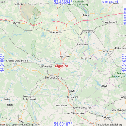
Cigacice GPS coordinates[2]
52° 2' 11.4" North, 15° 36' 47.52" East
| Map corner | latitude | longitude |
|---|---|---|
| Upper-left | 52.46694°, | 14.91008° |
| Center: | 52.0365°, | 15.6132° |
| Lower-right: | 51.60187°, | 16.31633° |
| Map W x H: | 96.2×96.2 km | = 59.8×59.8mi |
| max Lat: | 54.83135° ⇑33.8% North |
| Cigacice: | 52.0365° |
| min Lat: | ⇓66.2% South 49.21328° |
| min Long | Cigacice | max Long |
| 14.20249° | 15.6132° | 24.03723° |
| W 5.3%⇐ | ⇒94.7% E |
Elevation
Elevation of Cigacice is 80 m = 262 ft, and this is 111.4 m = 365 ft below average elevation for this country.
| Max E: |
974 m = 3196 ft | 88.4% |
| Avg. | 191.4 m = 628 ft | |
| Cigacice | 80 m = 262 ft | |
Min E: |
-3 m = -10 ft | 11.6% |
See also: Poland elevation on elevation.city.
Geographical zone
Cigacice is located in North temperate zone (between Tropic of Cancer and the Arctic Circle). Distance of this North polar circle is 1615.3 km =1003.7 mi to North.| Distance of | km | miles | from Cigacice |
|---|---|---|---|
| North Pole | 4221.1 | 2622.9 | to North |
| Arctic Circle | 1615.3 | 1003.7 | to North |
| Tropic Cancer | 3180 | 1976 | to South |
| Equator | 5785.9 | 3595.2 | to South |


Nearby cities:
15 places around Cigacice: (largest is in red/bold)
• Bojadła
16.4 km =10.2 mi,  124°
124°
• Brody
12.5 km =7.8 mi,  282°
282°
• Czerwieńsk
13.3 km =8.3 mi,  258°
258°
• Kargowa
17.4 km =10.8 mi,  77°
77°
• Kije
8.5 km =5.3 mi,  324°
324°
• Klenica
12.7 km =7.9 mi,  112°
112°
• Międzylesie
19.8 km =12.3 mi,  307°
307°
• Ochla
20 km =12.4 mi,  209°
209°
• Ploty
14.8 km =9.2 mi,  247°
247°
• Skąpe
16.7 km =10.4 mi, 320°
• Sulechów
5.3 km =3.3 mi,  8°
8°
• Swarzynice
10.3 km =6.4 mi, 112°
• Trzebiechów
8.6 km =5.3 mi,  101°
101°
• Zabór
11.8 km =7.3 mi,  142°
142°
• Zielona Góra
13.4 km =8.3 mi, 213°
Sources, notices
• [Note1] Compared only with cities in Poland existing in our database
• [Src1] Map data: © OpenStreetMap contributors (CC-BY-SA)
• [Src2] Other city data from geonames.org with taken over terms of usage.
• [Src3] Geographical zone / Annual Mean Temperature by Robert A. Rohde @ Wikipedia
