Klenica geodata
Klenica (Lubusz) is a populated place; located in Poland in Europe/Warsaw (GMT+2) time zone. With population of 1,400 people, there are 1959 cities with bigger population in this country. Compared to other cities in Poland, 65.6% of cities are located further ↓South; 93.7% of cities are located further →East and 93.6% of cities have higher elevation than Klenica. Note1


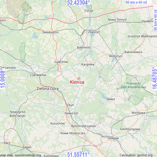
Klenica GPS coordinates[2]
51° 59' 31.812" North, 15° 47' 2.112" East
| Map corner | latitude | longitude |
|---|---|---|
| Upper-left | 52.42304°, | 15.0808° |
| Center: | 51.99217°, | 15.78392° |
| Lower-right: | 51.55711°, | 16.48705° |
| Map W x H: | 96.3×96.3 km | = 59.8×59.8mi |
| max Lat: | 54.83135° ⇑34.4% North |
| Klenica: | 51.99217° |
| min Lat: | ⇓65.6% South 49.21328° |
| min Long | Klenica | max Long |
| 14.20249° | 15.78392° | 24.03723° |
| W 6.3%⇐ | ⇒93.7% E |
Elevation
Elevation of Klenica is 56 m = 184 ft, and this is 135.4 m = 444 ft below average elevation for this country.
| Max E: |
974 m = 3196 ft | 93.6% |
| Avg. | 191.4 m = 628 ft | |
| Klenica | 56 m = 184 ft | |
Min E: |
-3 m = -10 ft | 6.4% |
See also: Poland elevation on elevation.city.
Geographical zone
Klenica is located in North temperate zone (between Tropic of Cancer and the Arctic Circle). Distance of this North polar circle is 1620.2 km =1006.7 mi to North.| Distance of | km | miles | from Klenica |
|---|---|---|---|
| North Pole | 4226.1 | 2626 | to North |
| Arctic Circle | 1620.2 | 1006.7 | to North |
| Tropic Cancer | 3175.1 | 1972.9 | to South |
| Equator | 5781 | 3592.1 | to South |


Nearby cities:
15 places around Klenica: (largest is in red/bold)
• Babimost
19.4 km =12.1 mi,  8°
8°
• Bobrowniki
14.6 km =9.1 mi,  194°
194°
• Bojadła
4.7 km =2.9 mi,  157°
157°
• Cigacice
12.7 km =7.9 mi,  292°
292°
• Kargowa
10.3 km =6.4 mi,  31°
31°
• Kije
20.4 km =12.7 mi,  305°
305°
• Kolsko
12.5 km =7.8 mi,  105°
105°
• Konotop
10.6 km =6.6 mi,  129°
129°
• Lubięcin
13 km =8.1 mi,  150°
150°
• Otyń
16.8 km =10.4 mi,  197°
197°
• Sulechów
14.9 km =9.3 mi, 313°
• Swarzynice
2.4 km =1.5 mi, 293°
• Trzebiechów
4.6 km =2.9 mi, 314°
• Zabór
6.4 km =4 mi,  225°
225°
• Zielona Góra
20 km =12.4 mi,  251°
251°
Sources, notices
• [Note1] Compared only with cities in Poland existing in our database
• [Src1] Map data: © OpenStreetMap contributors (CC-BY-SA)
• [Src2] Other city data from geonames.org with taken over terms of usage.
• [Src3] Geographical zone / Annual Mean Temperature by Robert A. Rohde @ Wikipedia
