Zielona Góra geodata
Zielona Góra (Lubusz) is a seat of a first-order administrative division; located in Poland in Europe/Warsaw (GMT+2) time zone. With population of 118,433 people, there are 40 cities with bigger population in this country. Compared to other cities in Poland, 64.4% of cities are located further ↓South; 95.4% of cities are located further →East and 61.5% of cities have higher elevation than Zielona Góra. Note1


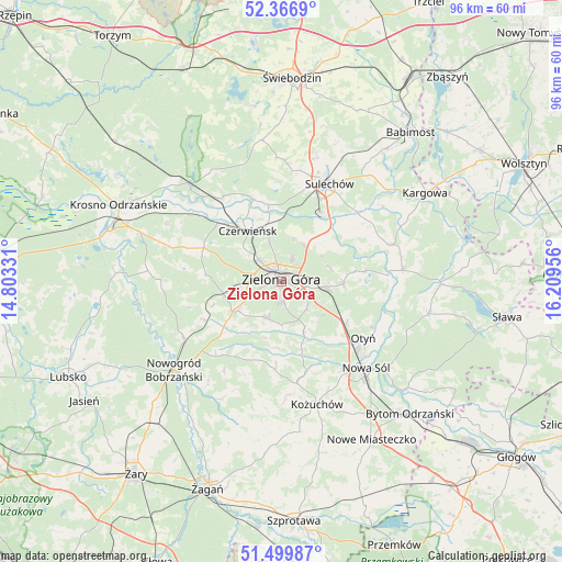
Zielona Góra GPS coordinates[2]
51° 56' 7.728" North, 15° 30' 23.148" East
| Map corner | latitude | longitude |
|---|---|---|
| Upper-left | 52.3669°, | 14.80331° |
| Center: | 51.93548°, | 15.50643° |
| Lower-right: | 51.49987°, | 16.20956° |
| Map W x H: | 96.4×96.4 km | = 59.9×59.9mi |
| max Lat: | 54.83135° ⇑35.6% North |
| Zielona Góra: | 51.93548° |
| min Lat: | ⇓64.4% South 49.21328° |
| min Long | Zielona Góra | max Long |
| 14.20249° | 15.50643° | 24.03723° |
| W 4.6%⇐ | ⇒95.4% E |
Elevation
Elevation of Zielona Góra is 143 m = 469 ft, and this is 48.4 m = 159 ft below average elevation for this country.
| Max E: |
974 m = 3196 ft | 61.5% |
| Avg. | 191.4 m = 628 ft | |
| Zielona Góra | 143 m = 469 ft | |
Min E: |
-3 m = -10 ft | 38.5% |
See also: Zielona Góra elevation on elevation.city.
Geographical zone
Zielona Góra is located in North temperate zone (between Tropic of Cancer and the Arctic Circle). Distance of this North polar circle is 1626.5 km =1010.7 mi to North.| Distance of | km | miles | from Zielona Góra |
|---|---|---|---|
| North Pole | 4232.4 | 2629.9 | to North |
| Arctic Circle | 1626.5 | 1010.7 | to North |
| Tropic Cancer | 3168.8 | 1969 | to South |
| Equator | 5774.7 | 3588.2 | to South |


Nearby cities:
15 places around Zielona Góra: (largest is in red/bold)
• Bobrowniki
17.3 km =10.7 mi,  116°
116°
• Brody
14.8 km =9.2 mi,  340°
340°
• Cigacice
13.4 km =8.3 mi,  33°
33°
• Czerwieńsk
10.3 km =6.4 mi,  326°
326°
• Kaczeniec
16.7 km =10.4 mi,  222°
222°
• Kije
18.3 km =11.4 mi,  7°
7°
• Niwiska
15 km =9.3 mi,  211°
211°
• Ochla
6.7 km =4.2 mi,  200°
200°
• Otyń
17.1 km =10.6 mi, 124°
• Ploty
8.5 km =5.3 mi,  311°
311°
• Sulechów
18.4 km =11.4 mi, 26°
• Swarzynice
18.3 km =11.4 mi,  66°
66°
• Trzebiechów
18.4 km =11.4 mi,  58°
58°
• Zabór
14.5 km =9 mi,  82°
82°
• Świdnica
9.5 km =5.9 mi,  236°
236°
Sources, notices
• [Note1] Compared only with cities in Poland existing in our database
• [Src1] Map data: © OpenStreetMap contributors (CC-BY-SA)
• [Src2] Other city data from geonames.org with taken over terms of usage.
• [Src3] Geographical zone / Annual Mean Temperature by Robert A. Rohde @ Wikipedia
