Pierściec geodata
Pierściec (Silesia) is a populated place; located in Poland in Europe/Warsaw (GMT+2) time zone. With population of 2,111 people, there are 1407 cities with bigger population in this country. Compared to other cities in Poland, 90.5% of cities are located further ↑North; 63.1% of cities are located further →East and 85.4% of cities have lower elevation than Pierściec. Note1


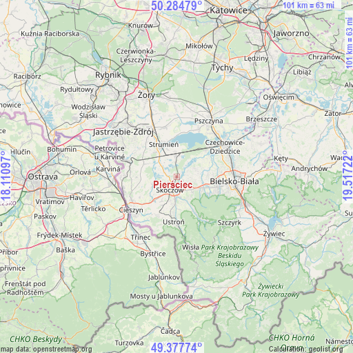
Pierściec GPS coordinates[2]
49° 50' 0.204" North, 18° 48' 50.724" East
| Map corner | latitude | longitude |
|---|---|---|
| Upper-left | 50.28479°, | 18.11097° |
| Center: | 49.83339°, | 18.81409° |
| Lower-right: | 49.37774°, | 19.51722° |
| Map W x H: | 100.9×100.9 km | = 62.7×62.7mi |
| max Lat: | 54.83135° ⇑90.5% North |
| Pierściec: | 49.83339° |
| min Lat: | ⇓9.5% South 49.21328° |
| min Long | Pierściec | max Long |
| 14.20249° | 18.81409° | 24.03723° |
| W 36.9%⇐ | ⇒63.1% E |
Elevation
Elevation of Pierściec is 292 m = 958 ft, and this is 100.6 m = 330 ft above average elevation for this country.
| Max E: |
974 m = 3196 ft | 14.6% |
| Pierściec | 292 m 958 ft | |
| Avg. | 191.4 m = 628 ft | |
Min E: |
-3 m = -10 ft | 85.4% |
See also: Poland elevation on elevation.city.
Geographical zone
Pierściec is located in North temperate zone (between Tropic of Cancer and the Arctic Circle). Distance of this North polar circle is 1860.2 km =1155.9 mi to North.| Distance of | km | miles | from Pierściec |
|---|---|---|---|
| North Pole | 4466.1 | 2775.1 | to North |
| Arctic Circle | 1860.2 | 1155.9 | to North |
| Tropic Cancer | 2935 | 1823.7 | to South |
| Equator | 5541 | 3443 | to South |


Nearby cities:
15 places around Pierściec: (largest is in red/bold)
• Bładnice
6.6 km =4.1 mi,  202°
202°
• Drogomyśl
5.7 km =3.5 mi,  314°
314°
• Górki Wielkie
6.1 km =3.8 mi,  168°
168°
• Harbutowice
6 km =3.7 mi,  184°
184°
• Iskrzyczyn
6.5 km =4 mi,  230°
230°
• Kiczyce
1.3 km =0.8 mi,  221°
221°
• Kowale
2 km =1.2 mi,  113°
113°
• Miedzyświec
6.5 km =4 mi,  212°
212°
• Mnich
6.3 km =3.9 mi,  355°
355°
• Ochaby
3.4 km =2.1 mi,  287°
287°
• Pogórze
4.3 km =2.7 mi,  150°
150°
• Simoradz
4.6 km =2.9 mi,  238°
238°
• Skoczów
4.1 km =2.5 mi, 207°
• Wiślica
2.6 km =1.6 mi, 238°
• Zaborze
4.4 km =2.7 mi,  350°
350°
Sources, notices
• [Note1] Compared only with cities in Poland existing in our database
• [Src1] Map data: © OpenStreetMap contributors (CC-BY-SA)
• [Src2] Other city data from geonames.org with taken over terms of usage.
• [Src3] Geographical zone / Annual Mean Temperature by Robert A. Rohde @ Wikipedia
