Bogunice geodata
Bogunice (Silesia) is a populated place; located in Poland in Europe/Warsaw (GMT+2) time zone. With population of 773 people, there are 2918 cities with bigger population in this country. Compared to other cities in Poland, 76.5% of cities are located further ↑North; 70.3% of cities are located further →East and 67.4% of cities have lower elevation than Bogunice. Note1


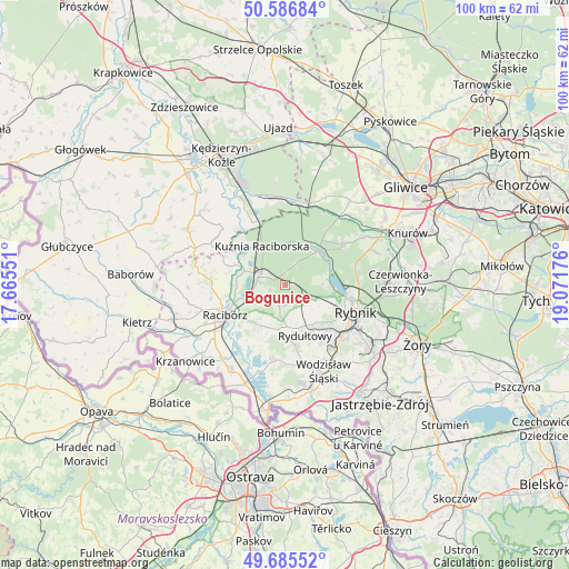
Bogunice GPS coordinates[2]
50° 8' 17.88" North, 18° 22' 7.068" East
| Map corner | latitude | longitude |
|---|---|---|
| Upper-left | 50.58684°, | 17.66551° |
| Center: | 50.1383°, | 18.36863° |
| Lower-right: | 49.68552°, | 19.07176° |
| Map W x H: | 100.2×100.2 km | = 62.3×62.3mi |
| max Lat: | 54.83135° ⇑76.5% North |
| Bogunice: | 50.1383° |
| min Lat: | ⇓23.5% South 49.21328° |
| min Long | Bogunice | max Long |
| 14.20249° | 18.36863° | 24.03723° |
| W 29.7%⇐ | ⇒70.3% E |
Elevation
Elevation of Bogunice is 221 m = 725 ft, and this is 29.6 m = 97 ft above average elevation for this country.
| Max E: |
974 m = 3196 ft | 32.6% |
| Bogunice | 221 m 725 ft | |
| Avg. | 191.4 m = 628 ft | |
Min E: |
-3 m = -10 ft | 67.4% |
See also: Poland elevation on elevation.city.
Geographical zone
Bogunice is located in North temperate zone (between Tropic of Cancer and the Arctic Circle). Distance of this North polar circle is 1826.3 km =1134.8 mi to North.| Distance of | km | miles | from Bogunice |
|---|---|---|---|
| North Pole | 4432.2 | 2754 | to North |
| Arctic Circle | 1826.3 | 1134.8 | to North |
| Tropic Cancer | 2968.9 | 1844.8 | to South |
| Equator | 5574.9 | 3464.1 | to South |


Nearby cities:
15 places around Bogunice: (largest is in red/bold)
• Adamowice
2.6 km =1.6 mi,  254°
254°
• Babice
5.1 km =3.2 mi,  275°
275°
• Czernica
6.5 km =4 mi,  159°
159°
• Gaszowice
5.5 km =3.4 mi,  126°
126°
• Górki Śląskie
1.4 km =0.9 mi,  75°
75°
• Jejkowice
7.8 km =4.8 mi,  115°
115°
• Kobyła
6.9 km =4.3 mi,  221°
221°
• Kornowac
7.9 km =4.9 mi,  201°
201°
• Kuźnia Raciborska
8 km =5 mi,  329°
329°
• Lyski
2.6 km =1.6 mi,  141°
141°
• Nędza
4.8 km =3 mi,  301°
301°
• Pogrzebień
9.3 km =5.8 mi,  212°
212°
• Raszczyce
5.2 km =3.2 mi, 249°
• Rudy
8.3 km =5.2 mi,  46°
46°
• Szczerbice
7.5 km =4.7 mi, 130°
Sources, notices
• [Note1] Compared only with cities in Poland existing in our database
• [Src1] Map data: © OpenStreetMap contributors (CC-BY-SA)
• [Src2] Other city data from geonames.org with taken over terms of usage.
• [Src3] Geographical zone / Annual Mean Temperature by Robert A. Rohde @ Wikipedia
