Pogrzebień geodata
Pogrzebień (Silesia) is a populated place; located in Poland in Europe/Warsaw (GMT+2) time zone. With population of 1,215 people, there are 2151 cities with bigger population in this country. Compared to other cities in Poland, 79.3% of cities are located further ↑North; 71.4% of cities are located further →East and 83.7% of cities have lower elevation than Pogrzebień. Note1


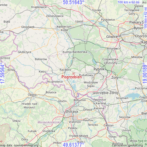
Pogrzebień GPS coordinates[2]
50° 4' 1.992" North, 18° 17' 55.536" East
| Map corner | latitude | longitude |
|---|---|---|
| Upper-left | 50.51643°, | 17.59564° |
| Center: | 50.06722°, | 18.29876° |
| Lower-right: | 49.61377°, | 19.00189° |
| Map W x H: | 100.4×100.4 km | = 62.4×62.4mi |
| max Lat: | 54.83135° ⇑79.3% North |
| Pogrzebień: | 50.06722° |
| min Lat: | ⇓20.7% South 49.21328° |
| min Long | Pogrzebień | max Long |
| 14.20249° | 18.29876° | 24.03723° |
| W 28.6%⇐ | ⇒71.4% E |
Elevation
Elevation of Pogrzebień is 284 m = 932 ft, and this is 92.6 m = 304 ft above average elevation for this country.
| Max E: |
974 m = 3196 ft | 16.3% |
| Pogrzebień | 284 m 932 ft | |
| Avg. | 191.4 m = 628 ft | |
Min E: |
-3 m = -10 ft | 83.7% |
See also: Poland elevation on elevation.city.
Geographical zone
Pogrzebień is located in North temperate zone (between Tropic of Cancer and the Arctic Circle). Distance of this North polar circle is 1834.2 km =1139.7 mi to North.| Distance of | km | miles | from Pogrzebień |
|---|---|---|---|
| North Pole | 4440.1 | 2758.9 | to North |
| Arctic Circle | 1834.2 | 1139.7 | to North |
| Tropic Cancer | 2961 | 1839.9 | to South |
| Equator | 5567 | 3459.2 | to South |


Nearby cities:
15 places around Pogrzebień: (largest is in red/bold)
• Adamowice
7.6 km =4.7 mi,  18°
18°
• Babice
8.4 km =5.2 mi,  359°
359°
• Bogunice
9.3 km =5.8 mi,  32°
32°
• Czernica
7.5 km =4.7 mi,  75°
75°
• Kobyła
2.8 km =1.7 mi,  8°
8°
• Kornowac
2.2 km =1.4 mi, 76°
• Lubomia
3.1 km =1.9 mi,  167°
167°
• Lyski
8.8 km =5.5 mi,  48°
48°
• Nieboczowy
3.8 km =2.4 mi,  227°
227°
• Pszów
7.5 km =4.7 mi,  113°
113°
• Racibórz
6.3 km =3.9 mi,  295°
295°
• Raszczyce
6.1 km =3.8 mi,  0°
0°
• Rydułtowy
8.5 km =5.3 mi,  96°
96°
• Syrynia
6.2 km =3.9 mi,  147°
147°
• Tworków
8.2 km =5.1 mi,  213°
213°
Sources, notices
• [Note1] Compared only with cities in Poland existing in our database
• [Src1] Map data: © OpenStreetMap contributors (CC-BY-SA)
• [Src2] Other city data from geonames.org with taken over terms of usage.
• [Src3] Geographical zone / Annual Mean Temperature by Robert A. Rohde @ Wikipedia
