Kornowac geodata
Kornowac (Silesia) is a seat of a third-order administrative division; located in Poland in Europe/Warsaw (GMT+2) time zone. With population of 749 people, there are 2973 cities with bigger population in this country. Compared to other cities in Poland, 79.1% of cities are located further ↑North; 70.9% of cities are located further →East and 79.8% of cities have lower elevation than Kornowac. Note1


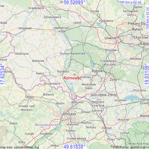
Kornowac GPS coordinates[2]
50° 4' 18.444" North, 18° 19' 42.456" East
| Map corner | latitude | longitude |
|---|---|---|
| Upper-left | 50.52095°, | 17.62534° |
| Center: | 50.07179°, | 18.32846° |
| Lower-right: | 49.61838°, | 19.03159° |
| Map W x H: | 100.4×100.4 km | = 62.4×62.4mi |
| max Lat: | 54.83135° ⇑79.1% North |
| Kornowac: | 50.07179° |
| min Lat: | ⇓20.9% South 49.21328° |
| min Long | Kornowac | max Long |
| 14.20249° | 18.32846° | 24.03723° |
| W 29.1%⇐ | ⇒70.9% E |
Elevation
Elevation of Kornowac is 265 m = 869 ft, and this is 73.6 m = 241 ft above average elevation for this country.
| Max E: |
974 m = 3196 ft | 20.2% |
| Kornowac | 265 m 869 ft | |
| Avg. | 191.4 m = 628 ft | |
Min E: |
-3 m = -10 ft | 79.8% |
See also: Poland elevation on elevation.city.
Geographical zone
Kornowac is located in North temperate zone (between Tropic of Cancer and the Arctic Circle). Distance of this North polar circle is 1833.7 km =1139.4 mi to North.| Distance of | km | miles | from Kornowac |
|---|---|---|---|
| North Pole | 4439.6 | 2758.6 | to North |
| Arctic Circle | 1833.7 | 1139.4 | to North |
| Tropic Cancer | 2961.5 | 1840.2 | to South |
| Equator | 5567.5 | 3459.5 | to South |


Nearby cities:
15 places around Kornowac: (largest is in red/bold)
• Adamowice
6.7 km =4.2 mi,  2°
2°
• Babice
8.2 km =5.1 mi,  344°
344°
• Bogunice
7.9 km =4.9 mi,  21°
21°
• Czernica
5.3 km =3.3 mi,  75°
75°
• Gaszowice
8.3 km =5.2 mi,  60°
60°
• Kobyła
2.9 km =1.8 mi,  322°
322°
• Lubomia
3.8 km =2.4 mi,  202°
202°
• Lyski
7 km =4.3 mi,  40°
40°
• Nieboczowy
5.8 km =3.6 mi,  237°
237°
• Pogrzebień
2.2 km =1.4 mi,  256°
256°
• Pszów
5.9 km =3.7 mi,  126°
126°
• Racibórz
8.1 km =5 mi,  286°
286°
• Raszczyce
5.9 km =3.7 mi, 339°
• Rydułtowy
6.5 km =4 mi,  103°
103°
• Syrynia
5.9 km =3.7 mi,  167°
167°
Sources, notices
• [Note1] Compared only with cities in Poland existing in our database
• [Src1] Map data: © OpenStreetMap contributors (CC-BY-SA)
• [Src2] Other city data from geonames.org with taken over terms of usage.
• [Src3] Geographical zone / Annual Mean Temperature by Robert A. Rohde @ Wikipedia
