Czernica geodata
Czernica (Silesia) is a populated place; located in Poland in Europe/Warsaw (GMT+2) time zone. With population of 2,100 people, there are 1411 cities with bigger population in this country. Compared to other cities in Poland, 78.7% of cities are located further ↑North; 69.7% of cities are located further →East and 76% of cities have lower elevation than Czernica. Note1


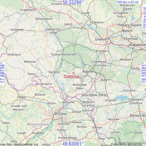
Czernica GPS coordinates[2]
50° 5' 2.076" North, 18° 24' 2.448" East
| Map corner | latitude | longitude |
|---|---|---|
| Upper-left | 50.53296°, | 17.69756° |
| Center: | 50.08391°, | 18.40068° |
| Lower-right: | 49.63061°, | 19.10381° |
| Map W x H: | 100.3×100.3 km | = 62.3×62.3mi |
| max Lat: | 54.83135° ⇑78.7% North |
| Czernica: | 50.08391° |
| min Lat: | ⇓21.3% South 49.21328° |
| min Long | Czernica | max Long |
| 14.20249° | 18.40068° | 24.03723° |
| W 30.3%⇐ | ⇒69.7% E |
Elevation
Elevation of Czernica is 250 m = 820 ft, and this is 58.6 m = 192 ft above average elevation for this country.
| Max E: |
974 m = 3196 ft | 24% |
| Czernica | 250 m 820 ft | |
| Avg. | 191.4 m = 628 ft | |
Min E: |
-3 m = -10 ft | 76% |
See also: Poland elevation on elevation.city.
Geographical zone
Czernica is located in North temperate zone (between Tropic of Cancer and the Arctic Circle). Distance of this North polar circle is 1832.4 km =1138.6 mi to North.| Distance of | km | miles | from Czernica |
|---|---|---|---|
| North Pole | 4438.3 | 2757.8 | to North |
| Arctic Circle | 1832.4 | 1138.6 | to North |
| Tropic Cancer | 2962.9 | 1841.1 | to South |
| Equator | 5568.8 | 3460.3 | to South |


Nearby cities:
15 places around Czernica: (largest is in red/bold)
• Adamowice
7.2 km =4.5 mi,  317°
317°
• Bogunice
6.5 km =4 mi,  339°
339°
• Gaszowice
3.5 km =2.2 mi,  37°
37°
• Górki Śląskie
6.5 km =4 mi,  351°
351°
• Jejkowice
5.5 km =3.4 mi,  60°
60°
• Kobyła
6.9 km =4.3 mi,  277°
277°
• Kornowac
5.3 km =3.3 mi,  255°
255°
• Lyski
4.1 km =2.5 mi, 350°
• Niedobczyce
7.1 km =4.4 mi,  106°
106°
• Pogrzebień
7.5 km =4.7 mi, 255°
• Pszów
4.9 km =3 mi,  184°
184°
• Radlin
6.6 km =4.1 mi,  124°
124°
• Rydułtowy
3 km =1.9 mi,  157°
157°
• Szczerbice
3.6 km =2.2 mi,  71°
71°
• Zebrzydowice
7.3 km =4.5 mi,  75°
75°
Sources, notices
• [Note1] Compared only with cities in Poland existing in our database
• [Src1] Map data: © OpenStreetMap contributors (CC-BY-SA)
• [Src2] Other city data from geonames.org with taken over terms of usage.
• [Src3] Geographical zone / Annual Mean Temperature by Robert A. Rohde @ Wikipedia
