Radzionków geodata
Radzionków (Silesia) is a populated place; located in Poland in Europe/Warsaw (GMT+2) time zone. With population of 17,167 people, there are 287 cities with bigger population in this country. Compared to other cities in Poland, 69.5% of cities are located further ↑North; 61.9% of cities are located further →East and 86.4% of cities have lower elevation than Radzionków. Note1


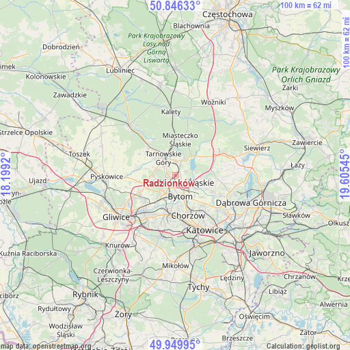
Radzionków GPS coordinates[2]
50° 24' 0.936" North, 18° 54' 8.352" East
| Map corner | latitude | longitude |
|---|---|---|
| Upper-left | 50.84633°, | 18.1992° |
| Center: | 50.40026°, | 18.90232° |
| Lower-right: | 49.94995°, | 19.60545° |
| Map W x H: | 99.7×99.7 km | = 62×62mi |
| max Lat: | 54.83135° ⇑69.5% North |
| Radzionków: | 50.40026° |
| min Lat: | ⇓30.5% South 49.21328° |
| min Long | Radzionków | max Long |
| 14.20249° | 18.90232° | 24.03723° |
| W 38.1%⇐ | ⇒61.9% E |
Elevation
Elevation of Radzionków is 298 m = 978 ft, and this is 106.6 m = 350 ft above average elevation for this country.
| Max E: |
974 m = 3196 ft | 13.6% |
| Radzionków | 298 m 978 ft | |
| Avg. | 191.4 m = 628 ft | |
Min E: |
-3 m = -10 ft | 86.4% |
See also: Poland elevation on elevation.city.
Geographical zone
Radzionków is located in North temperate zone (between Tropic of Cancer and the Arctic Circle). Distance of this North polar circle is 1797.2 km =1116.7 mi to North.| Distance of | km | miles | from Radzionków |
|---|---|---|---|
| North Pole | 4403.1 | 2736 | to North |
| Arctic Circle | 1797.2 | 1116.7 | to North |
| Tropic Cancer | 2998.1 | 1862.9 | to South |
| Equator | 5604 | 3482.2 | to South |


Nearby cities:
15 places around Radzionków: (largest is in red/bold)
• Bobrowniki
6.4 km =4 mi,  110°
110°
• Brzeziny Śląskie
7.6 km =4.7 mi,  132°
132°
• Bytom
6.2 km =3.9 mi,  159°
159°
• Dobieszowice
7.9 km =4.9 mi,  92°
92°
• Nakło
4.1 km =2.5 mi,  8°
8°
• Orzech
3.4 km =2.1 mi,  25°
25°
• Piekary Śląskie
2.8 km =1.7 mi,  142°
142°
• Rogoźnik
9.7 km =6 mi,  96°
96°
• Sączów
9.9 km =6.2 mi,  66°
66°
• Tarnowskie Góry
5.8 km =3.6 mi,  330°
330°
• Wieszowa
10.3 km =6.4 mi,  260°
260°
• Wojkowice
10.3 km =6.4 mi, 112°
• Wymysłów
6.1 km =3.8 mi,  78°
78°
• Zbrosławice
10.6 km =6.6 mi,  279°
279°
• Świerklaniec
5.3 km =3.3 mi, 27°
Sources, notices
• [Note1] Compared only with cities in Poland existing in our database
• [Src1] Map data: © OpenStreetMap contributors (CC-BY-SA)
• [Src2] Other city data from geonames.org with taken over terms of usage.
• [Src3] Geographical zone / Annual Mean Temperature by Robert A. Rohde @ Wikipedia
