Wymysłów geodata
Wymysłów (Silesia) is a populated place; located in Poland in Europe/Warsaw (GMT+2) time zone. With population of 572 people, there are 3353 cities with bigger population in this country. Compared to other cities in Poland, 69.2% of cities are located further ↑North; 60.2% of cities are located further →East and 86.2% of cities have lower elevation than Wymysłów. Note1


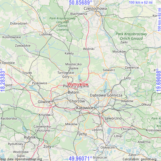
Wymysłów GPS coordinates[2]
50° 24' 39.312" North, 18° 59' 13.02" East
| Map corner | latitude | longitude |
|---|---|---|
| Upper-left | 50.85689°, | 18.28383° |
| Center: | 50.41092°, | 18.98695° |
| Lower-right: | 49.96071°, | 19.69008° |
| Map W x H: | 99.6×99.6 km | = 61.9×61.9mi |
| max Lat: | 54.83135° ⇑69.2% North |
| Wymysłów: | 50.41092° |
| min Lat: | ⇓30.8% South 49.21328° |
| min Long | Wymysłów | max Long |
| 14.20249° | 18.98695° | 24.03723° |
| W 39.8%⇐ | ⇒60.2% E |
Elevation
Elevation of Wymysłów is 297 m = 974 ft, and this is 105.6 m = 346 ft above average elevation for this country.
| Max E: |
974 m = 3196 ft | 13.8% |
| Wymysłów | 297 m 974 ft | |
| Avg. | 191.4 m = 628 ft | |
Min E: |
-3 m = -10 ft | 86.2% |
See also: Poland elevation on elevation.city.
Geographical zone
Wymysłów is located in North temperate zone (between Tropic of Cancer and the Arctic Circle). Distance of this North polar circle is 1796 km =1116 mi to North.| Distance of | km | miles | from Wymysłów |
|---|---|---|---|
| North Pole | 4401.9 | 2735.2 | to North |
| Arctic Circle | 1796 | 1116 | to North |
| Tropic Cancer | 2999.2 | 1863.6 | to South |
| Equator | 5605.2 | 3482.9 | to South |


Nearby cities:
15 places around Wymysłów: (largest is in red/bold)
• Bobrowniki
3.5 km =2.2 mi,  180°
180°
• Brzeziny Śląskie
6.3 km =3.9 mi, 183°
• Bytom
8 km =5 mi,  208°
208°
• Dobieszowice
2.4 km =1.5 mi,  129°
129°
• Nakło
6.1 km =3.8 mi,  298°
298°
• Orzech
4.9 km =3 mi,  291°
291°
• Ożarowice
6.9 km =4.3 mi,  35°
35°
• Piekary Śląskie
5.5 km =3.4 mi,  231°
231°
• Radzionków
6.1 km =3.8 mi,  258°
258°
• Rogoźnik
4.2 km =2.6 mi,  121°
121°
• Strzyżowice
7.1 km =4.4 mi,  111°
111°
• Sączów
4.1 km =2.5 mi,  48°
48°
• Tarnowskie Góry
9.7 km =6 mi, 293°
• Wojkowice
6.2 km =3.9 mi,  145°
145°
• Świerklaniec
5 km =3.1 mi,  314°
314°
Sources, notices
• [Note1] Compared only with cities in Poland existing in our database
• [Src1] Map data: © OpenStreetMap contributors (CC-BY-SA)
• [Src2] Other city data from geonames.org with taken over terms of usage.
• [Src3] Geographical zone / Annual Mean Temperature by Robert A. Rohde @ Wikipedia
