Bytom geodata
Bytom (Silesia) is a seat of a third-order administrative division; located in Poland in Europe/Warsaw (GMT+2) time zone. With population of 189,186 people, there are 20 cities with bigger population in this country. Compared to other cities in Poland, 70.9% of cities are located further ↑North; 61.3% of cities are located further →East and 83.9% of cities have lower elevation than Bytom. Note1


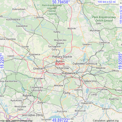
Bytom GPS coordinates[2]
50° 20' 52.872" North, 18° 55' 58.152" East
| Map corner | latitude | longitude |
|---|---|---|
| Upper-left | 50.79458°, | 18.2297° |
| Center: | 50.34802°, | 18.93282° |
| Lower-right: | 49.89722°, | 19.63595° |
| Map W x H: | 99.8×99.8 km | = 62×62mi |
| max Lat: | 54.83135° ⇑70.9% North |
| Bytom: | 50.34802° |
| min Lat: | ⇓29.1% South 49.21328° |
| min Long | Bytom | max Long |
| 14.20249° | 18.93282° | 24.03723° |
| W 38.7%⇐ | ⇒61.3% E |
Elevation
Elevation of Bytom is 285 m = 935 ft, and this is 93.6 m = 307 ft above average elevation for this country.
| Max E: |
974 m = 3196 ft | 16.1% |
| Bytom | 285 m 935 ft | |
| Avg. | 191.4 m = 628 ft | |
Min E: |
-3 m = -10 ft | 83.9% |
See also: Bytom elevation on elevation.city.
Geographical zone
Bytom is located in North temperate zone (between Tropic of Cancer and the Arctic Circle). Distance of this North polar circle is 1803 km =1120.3 mi to North.| Distance of | km | miles | from Bytom |
|---|---|---|---|
| North Pole | 4408.9 | 2739.6 | to North |
| Arctic Circle | 1803 | 1120.3 | to North |
| Tropic Cancer | 2992.3 | 1859.3 | to South |
| Equator | 5598.2 | 3478.6 | to South |


Nearby cities:
15 places around Bytom: (largest is in red/bold)
• Bobrowniki
5.2 km =3.2 mi,  47°
47°
• Brzeziny Śląskie
3.5 km =2.2 mi,  78°
78°
• Chorzów
5.5 km =3.4 mi,  147°
147°
• Dobieszowice
7.9 km =4.9 mi, 46°
• Nakło
10 km =6.2 mi,  350°
350°
• Orzech
8.9 km =5.5 mi,  355°
355°
• Piekary Śląskie
3.6 km =2.2 mi, 352°
• Radzionków
6.2 km =3.9 mi,  339°
339°
• Rogoźnik
8.8 km =5.5 mi,  57°
57°
• Siemianowice Śląskie
7.2 km =4.5 mi,  108°
108°
• Wojkowice
7.6 km =4.7 mi, 75°
• Wymysłów
8 km =5 mi,  28°
28°
• Zabrze
10.7 km =6.6 mi,  256°
256°
• Świerklaniec
10.5 km =6.5 mi,  1°
1°
• Świętochłowice
5.8 km =3.6 mi,  190°
190°
Sources, notices
• [Note1] Compared only with cities in Poland existing in our database
• [Src1] Map data: © OpenStreetMap contributors (CC-BY-SA)
• [Src2] Other city data from geonames.org with taken over terms of usage.
• [Src3] Geographical zone / Annual Mean Temperature by Robert A. Rohde @ Wikipedia
