Brody-Parcele geodata
Brody-Parcele (Mazovia) is a populated place; located in Poland in Europe/Warsaw (GMT+2) time zone. With population of 1,600 people, there are 1751 cities with bigger population in this country. Compared to other cities in Poland, 76.1% of cities are located further ↓South; 68.4% of cities are located further ←West and 89.6% of cities have higher elevation than Brody-Parcele. Note1


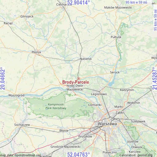
Brody-Parcele GPS coordinates[2]
52° 28' 40.692" North, 20° 44' 59.064" East
| Map corner | latitude | longitude |
|---|---|---|
| Upper-left | 52.90414°, | 20.04662° |
| Center: | 52.47797°, | 20.74974° |
| Lower-right: | 52.04763°, | 21.45287° |
| Map W x H: | 95.2×95.2 km | = 59.2×59.2mi |
| max Lat: | 54.83135° ⇑23.9% North |
| Brody-Parcele: | 52.47797° |
| min Lat: | ⇓76.1% South 49.21328° |
| min Long | Brody-Parcele | max Long |
| 14.20249° | 20.74974° | 24.03723° |
| W 68.4%⇐ | ⇒31.6% E |
Elevation
Elevation of Brody-Parcele is 77 m = 253 ft, and this is 114.4 m = 375 ft below average elevation for this country.
| Max E: |
974 m = 3196 ft | 89.6% |
| Avg. | 191.4 m = 628 ft | |
| Brody-Parcele | 77 m = 253 ft | |
Min E: |
-3 m = -10 ft | 10.4% |
See also: Poland elevation on elevation.city.
Geographical zone
Brody-Parcele is located in North temperate zone (between Tropic of Cancer and the Arctic Circle). Distance of this North polar circle is 1566.2 km =973.2 mi to North.| Distance of | km | miles | from Brody-Parcele |
|---|---|---|---|
| North Pole | 4172.1 | 2592.4 | to North |
| Arctic Circle | 1566.2 | 973.2 | to North |
| Tropic Cancer | 3229.1 | 2006.5 | to South |
| Equator | 5835 | 3625.7 | to South |


Nearby cities:
15 places around Brody-Parcele: (largest is in red/bold)
• Dziekanów Bajkowy
15 km =9.3 mi,  152°
152°
• Dziekanów Leśny
15.6 km =9.7 mi, 153°
• Jabłonna
15.8 km =9.8 mi,  134°
134°
• Kiełpin
15.4 km =9.6 mi, 150°
• Legionowo
14.7 km =9.1 mi, 125°
• Michałów-Reginów
16.1 km =10 mi,  114°
114°
• Nasielsk
12.9 km =8 mi,  17°
17°
• Nowy Dwór Mazowiecki
5.8 km =3.6 mi,  202°
202°
• Pomiechówek
1.6 km =1 mi,  242°
242°
• Stanisławów
16.3 km =10.1 mi,  117°
117°
• Wieliszew
15.1 km =9.4 mi,  101°
101°
• Zakroczym
10.6 km =6.6 mi, 242°
• Załuski
15.4 km =9.6 mi,  283°
283°
• Łajski
14.6 km =9.1 mi, 112°
• Łomna
10.8 km =6.7 mi,  169°
169°
Sources, notices
• [Note1] Compared only with cities in Poland existing in our database
• [Src1] Map data: © OpenStreetMap contributors (CC-BY-SA)
• [Src2] Other city data from geonames.org with taken over terms of usage.
• [Src3] Geographical zone / Annual Mean Temperature by Robert A. Rohde @ Wikipedia
