Załuski geodata
Załuski (Mazovia) is a seat of a third-order administrative division; located in Poland in Europe/Warsaw (GMT+2) time zone. With population of 402 people, there are 3588 cities with bigger population in this country. Compared to other cities in Poland, 76.6% of cities are located further ↓South; 65.4% of cities are located further ←West and 75% of cities have higher elevation than Załuski. Note1


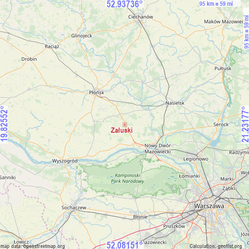
Załuski GPS coordinates[2]
52° 30' 41.472" North, 20° 31' 43.104" East
| Map corner | latitude | longitude |
|---|---|---|
| Upper-left | 52.93736°, | 19.82552° |
| Center: | 52.51152°, | 20.52864° |
| Lower-right: | 52.08151°, | 21.23177° |
| Map W x H: | 95.2×95.2 km | = 59.2×59.2mi |
| max Lat: | 54.83135° ⇑23.4% North |
| Załuski: | 52.51152° |
| min Lat: | ⇓76.6% South 49.21328° |
| min Long | Załuski | max Long |
| 14.20249° | 20.52864° | 24.03723° |
| W 65.4%⇐ | ⇒34.6% E |
Elevation
Elevation of Załuski is 111 m = 364 ft, and this is 80.4 m = 264 ft below average elevation for this country.
| Max E: |
974 m = 3196 ft | 75% |
| Avg. | 191.4 m = 628 ft | |
| Załuski | 111 m = 364 ft | |
Min E: |
-3 m = -10 ft | 25% |
See also: Poland elevation on elevation.city.
Geographical zone
Załuski is located in North temperate zone (between Tropic of Cancer and the Arctic Circle). Distance of this North polar circle is 1562.4 km =970.8 mi to North.| Distance of | km | miles | from Załuski |
|---|---|---|---|
| North Pole | 4168.3 | 2590.1 | to North |
| Arctic Circle | 1562.4 | 970.8 | to North |
| Tropic Cancer | 3232.8 | 2008.8 | to South |
| Equator | 5838.7 | 3628 | to South |


Nearby cities:
15 places around Załuski: (largest is in red/bold)
• Baboszewo
26.4 km =16.4 mi,  315°
315°
• Brody-Parcele
15.4 km =9.6 mi,  103°
103°
• Czerwińsk Nad Wisłą
19.5 km =12.1 mi,  229°
229°
• Dzierzążnia
23.8 km =14.8 mi,  303°
303°
• Joniec
10.6 km =6.6 mi,  19°
19°
• Naruszewo
12.1 km =7.5 mi,  278°
278°
• Nasielsk
20.6 km =12.8 mi,  65°
65°
• Nowe Miasto
17.5 km =10.9 mi, 22°
• Nowy Dwór Mazowiecki
15.6 km =9.7 mi,  125°
125°
• Pomiechówek
14.3 km =8.9 mi,  108°
108°
• Płońsk
16.2 km =10.1 mi, 320°
• Sochocin
19.9 km =12.4 mi,  349°
349°
• Zakroczym
10.4 km =6.5 mi,  146°
146°
• Łomna
22.2 km =13.8 mi, 130°
• Świercze
23.8 km =14.8 mi,  41°
41°
Sources, notices
• [Note1] Compared only with cities in Poland existing in our database
• [Src1] Map data: © OpenStreetMap contributors (CC-BY-SA)
• [Src2] Other city data from geonames.org with taken over terms of usage.
• [Src3] Geographical zone / Annual Mean Temperature by Robert A. Rohde @ Wikipedia
