Zakroczym geodata
Zakroczym (Mazovia) is a seat of a third-order administrative division; located in Poland in Europe/Warsaw (GMT+2) time zone. With population of 3,347 people, there are 956 cities with bigger population in this country. Compared to other cities in Poland, 75.4% of cities are located further ↓South; 66.5% of cities are located further ←West and 82.7% of cities have higher elevation than Zakroczym. Note1


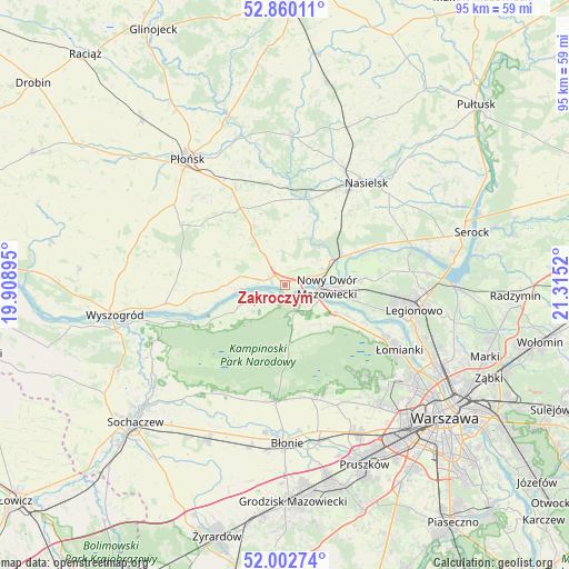
Zakroczym GPS coordinates[2]
52° 26' 0.636" North, 20° 36' 43.452" East
| Map corner | latitude | longitude |
|---|---|---|
| Upper-left | 52.86011°, | 19.90895° |
| Center: | 52.43351°, | 20.61207° |
| Lower-right: | 52.00274°, | 21.3152° |
| Map W x H: | 95.3×95.3 km | = 59.2×59.2mi |
| max Lat: | 54.83135° ⇑24.6% North |
| Zakroczym: | 52.43351° |
| min Lat: | ⇓75.4% South 49.21328° |
| min Long | Zakroczym | max Long |
| 14.20249° | 20.61207° | 24.03723° |
| W 66.5%⇐ | ⇒33.5% E |
Elevation
Elevation of Zakroczym is 94 m = 308 ft, and this is 97.4 m = 320 ft below average elevation for this country.
| Max E: |
974 m = 3196 ft | 82.7% |
| Avg. | 191.4 m = 628 ft | |
| Zakroczym | 94 m = 308 ft | |
Min E: |
-3 m = -10 ft | 17.3% |
See also: Poland elevation on elevation.city.
Geographical zone
Zakroczym is located in North temperate zone (between Tropic of Cancer and the Arctic Circle). Distance of this North polar circle is 1571.1 km =976.2 mi to North.| Distance of | km | miles | from Zakroczym |
|---|---|---|---|
| North Pole | 4177 | 2595.5 | to North |
| Arctic Circle | 1571.1 | 976.2 | to North |
| Tropic Cancer | 3224.1 | 2003.4 | to South |
| Equator | 5830.1 | 3622.7 | to South |


Nearby cities:
15 places around Zakroczym: (largest is in red/bold)
• Brody-Parcele
10.6 km =6.6 mi,  62°
62°
• Czerwińsk Nad Wisłą
20.9 km =13 mi,  259°
259°
• Dziekanów Bajkowy
18.3 km =11.4 mi,  117°
117°
• Dziekanów Leśny
18.6 km =11.6 mi, 119°
• Izabelin
20.4 km =12.7 mi,  136°
136°
• Joniec
18.8 km =11.7 mi,  353°
353°
• Kiełpin
18.9 km =11.7 mi, 116°
• Leszno
19.6 km =12.2 mi,  184°
184°
• Naruszewo
20.5 km =12.7 mi,  300°
300°
• Nowy Dwór Mazowiecki
7.1 km =4.4 mi,  92°
92°
• Pomiechówek
9 km =5.6 mi, 62°
• Truskaw
18.7 km =11.6 mi, 141°
• Zaborów
19.5 km =12.1 mi,  166°
166°
• Załuski
10.4 km =6.5 mi,  326°
326°
• Łomna
12.6 km =7.8 mi, 116°
Sources, notices
• [Note1] Compared only with cities in Poland existing in our database
• [Src1] Map data: © OpenStreetMap contributors (CC-BY-SA)
• [Src2] Other city data from geonames.org with taken over terms of usage.
• [Src3] Geographical zone / Annual Mean Temperature by Robert A. Rohde @ Wikipedia
