Malinówka geodata
Malinówka (Subcarpathian) is a populated place; located in Poland in Europe/Warsaw (GMT+2) time zone. With population of 927 people, there are 2627 cities with bigger population in this country. Compared to other cities in Poland, 94.6% of cities are located further ↑North; 83.8% of cities are located further ←West and 89% of cities have lower elevation than Malinówka. Note1


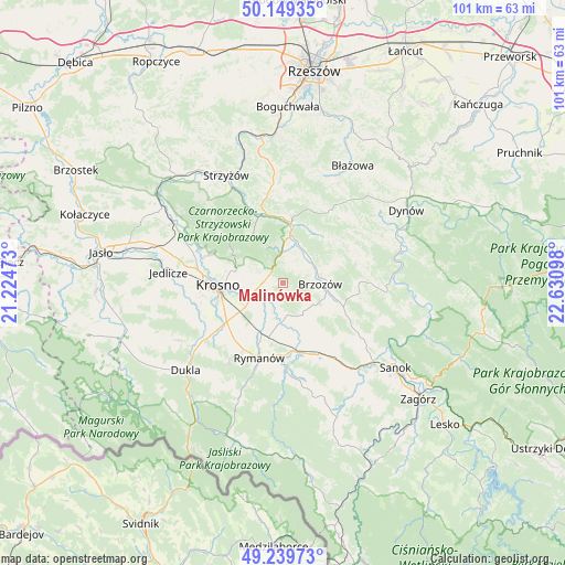
Malinówka GPS coordinates[2]
49° 41' 48.012" North, 21° 55' 40.26" East
| Map corner | latitude | longitude |
|---|---|---|
| Upper-left | 50.14935°, | 21.22473° |
| Center: | 49.69667°, | 21.92785° |
| Lower-right: | 49.23973°, | 22.63098° |
| Map W x H: | 101.1×101.1 km | = 62.8×62.8mi |
| max Lat: | 54.83135° ⇑94.6% North |
| Malinówka: | 49.69667° |
| min Lat: | ⇓5.4% South 49.21328° |
| min Long | Malinówka | max Long |
| 14.20249° | 21.92785° | 24.03723° |
| W 83.8%⇐ | ⇒16.2% E |
Elevation
Elevation of Malinówka is 317 m = 1040 ft, and this is 125.6 m = 412 ft above average elevation for this country.
| Max E: |
974 m = 3196 ft | 11% |
| Malinówka | 317 m 1040 ft | |
| Avg. | 191.4 m = 628 ft | |
Min E: |
-3 m = -10 ft | 89% |
See also: Poland elevation on elevation.city.
Geographical zone
Malinówka is located in North temperate zone (between Tropic of Cancer and the Arctic Circle). Distance of this North polar circle is 1875.4 km =1165.3 mi to North.| Distance of | km | miles | from Malinówka |
|---|---|---|---|
| North Pole | 4481.3 | 2784.5 | to North |
| Arctic Circle | 1875.4 | 1165.3 | to North |
| Tropic Cancer | 2919.8 | 1814.3 | to South |
| Equator | 5525.8 | 3433.6 | to South |


Nearby cities:
15 places around Malinówka: (largest is in red/bold)
• Blizne
7.1 km =4.4 mi,  27°
27°
• Brzozów
6.6 km =4.1 mi,  91°
91°
• Domaradz
10.1 km =6.3 mi,  7°
7°
• Górki
10.2 km =6.3 mi,  125°
125°
• Haczów
4.5 km =2.8 mi,  208°
208°
• Humniska
9.4 km =5.8 mi,  104°
104°
• Jabłonica Polska
2 km =1.2 mi,  273°
273°
• Jasienica Rosielna
6.2 km =3.9 mi, 9°
• Jasionów
5.5 km =3.4 mi,  140°
140°
• Korczyna
8.8 km =5.5 mi,  283°
283°
• Krościenko Wyżne
7.4 km =4.6 mi,  254°
254°
• Orzechówka
4 km =2.5 mi,  18°
18°
• Stara Wieś
5.9 km =3.7 mi,  69°
69°
• Turze Pole
6.7 km =4.2 mi,  123°
123°
• Zmiennica
3.5 km =2.2 mi, 129°
Sources, notices
• [Note1] Compared only with cities in Poland existing in our database
• [Src1] Map data: © OpenStreetMap contributors (CC-BY-SA)
• [Src2] Other city data from geonames.org with taken over terms of usage.
• [Src3] Geographical zone / Annual Mean Temperature by Robert A. Rohde @ Wikipedia
