Blizne geodata
Blizne (Subcarpathian) is a populated place; located in Poland in Europe/Warsaw (GMT+2) time zone. With population of 3,500 people, there are 911 cities with bigger population in this country. Compared to other cities in Poland, 93% of cities are located further ↑North; 84.6% of cities are located further ←West and 79.4% of cities have lower elevation than Blizne. Note1
Administrative division(s):
- Level 1: Subcarpathian
- Level 2: Powiat brzozowski
- Level 3: Jasienica Rosielna


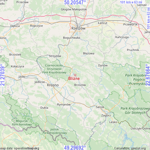
Blizne GPS coordinates[2]
49° 45' 11.952" North, 21° 58' 24.636" East
| Map corner | latitude | longitude |
|---|---|---|
| Upper-left | 50.20547°, | 21.27039° |
| Center: | 49.75332°, | 21.97351° |
| Lower-right: | 49.29692°, | 22.67664° |
| Map W x H: | 101×101 km | = 62.8×62.8mi |
| max Lat: | 54.83135° ⇑93% North |
| Blizne: | 49.75332° |
| min Lat: | ⇓7% South 49.21328° |
| min Long | Blizne | max Long |
| 14.20249° | 21.97351° | 24.03723° |
| W 84.6%⇐ | ⇒15.4% E |
Elevation
Elevation of Blizne is 263 m = 863 ft, and this is 71.6 m = 235 ft above average elevation for this country.
| Max E: |
974 m = 3196 ft | 20.6% |
| Blizne | 263 m 863 ft | |
| Avg. | 191.4 m = 628 ft | |
Min E: |
-3 m = -10 ft | 79.4% |
See also: Poland elevation on elevation.city.
Geographical zone
Blizne is located in North temperate zone (between Tropic of Cancer and the Arctic Circle). Distance of this North polar circle is 1869.1 km =1161.4 mi to North.| Distance of | km | miles | from Blizne |
|---|---|---|---|
| North Pole | 4475 | 2780.6 | to North |
| Arctic Circle | 1869.1 | 1161.4 | to North |
| Tropic Cancer | 2926.1 | 1818.2 | to South |
| Equator | 5532.1 | 3437.5 | to South |


Nearby cities:
15 places around Blizne: (largest is in red/bold)
• Brzozów
7.3 km =4.5 mi,  153°
153°
• Domaradz
4.2 km =2.6 mi,  331°
331°
• Golcowa
4.2 km =2.6 mi,  61°
61°
• Gwoźnica Górna
8.5 km =5.3 mi,  11°
11°
• Humniska
10.4 km =6.5 mi, 146°
• Jabłonica Polska
8.1 km =5 mi,  220°
220°
• Jasienica Rosielna
2.3 km =1.4 mi,  264°
264°
• Konieczkowa
10.4 km =6.5 mi,  341°
341°
• Krasna
9 km =5.6 mi,  286°
286°
• Malinówka
7.1 km =4.4 mi,  207°
207°
• Orzechówka
3.2 km =2 mi, 219°
• Stara Wieś
4.8 km =3 mi, 152°
• Turze Pole
10.3 km =6.4 mi,  167°
167°
• Wesoła
10.5 km =6.5 mi, 60°
• Zmiennica
8.6 km =5.3 mi,  183°
183°
Sources, notices
• [Note1] Compared only with cities in Poland existing in our database
• [Src1] Map data: © OpenStreetMap contributors (CC-BY-SA)
• [Src2] Other city data from geonames.org with taken over terms of usage.
• [Src3] Geographical zone / Annual Mean Temperature by Robert A. Rohde @ Wikipedia
