Haczów geodata
Haczów (Subcarpathian) is a seat of a third-order administrative division; located in Poland in Europe/Warsaw (GMT+2) time zone. With population of 3,370 people, there are 949 cities with bigger population in this country. Compared to other cities in Poland, 95.5% of cities are located further ↑North; 83.5% of cities are located further ←West and 83.7% of cities have lower elevation than Haczów. Note1


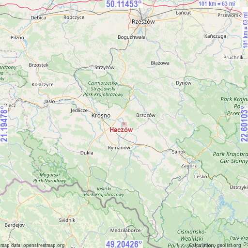
Haczów GPS coordinates[2]
49° 39' 41.472" North, 21° 53' 52.44" East
| Map corner | latitude | longitude |
|---|---|---|
| Upper-left | 50.11453°, | 21.19478° |
| Center: | 49.66152°, | 21.8979° |
| Lower-right: | 49.20426°, | 22.60103° |
| Map W x H: | 101.2×101.2 km | = 62.9×62.9mi |
| max Lat: | 54.83135° ⇑95.5% North |
| Haczów: | 49.66152° |
| min Lat: | ⇓4.5% South 49.21328° |
| min Long | Haczów | max Long |
| 14.20249° | 21.8979° | 24.03723° |
| W 83.5%⇐ | ⇒16.5% E |
Elevation
Elevation of Haczów is 284 m = 932 ft, and this is 92.6 m = 304 ft above average elevation for this country.
| Max E: |
974 m = 3196 ft | 16.3% |
| Haczów | 284 m 932 ft | |
| Avg. | 191.4 m = 628 ft | |
Min E: |
-3 m = -10 ft | 83.7% |
See also: Poland elevation on elevation.city.
Geographical zone
Haczów is located in North temperate zone (between Tropic of Cancer and the Arctic Circle). Distance of this North polar circle is 1879.3 km =1167.7 mi to North.| Distance of | km | miles | from Haczów |
|---|---|---|---|
| North Pole | 4485.2 | 2787 | to North |
| Arctic Circle | 1879.3 | 1167.7 | to North |
| Tropic Cancer | 2915.9 | 1811.9 | to South |
| Equator | 5521.8 | 3431.1 | to South |


Nearby cities:
15 places around Haczów: (largest is in red/bold)
• Besko
9.1 km =5.7 mi,  154°
154°
• Brzozów
9.5 km =5.9 mi,  66°
66°
• Jabłonica Polska
4 km =2.5 mi,  1°
1°
• Jasienica Rosielna
10.5 km =6.5 mi,  17°
17°
• Jasionów
5.7 km =3.5 mi,  93°
93°
• Korczyna
8.8 km =5.5 mi,  313°
313°
• Krosno
9.6 km =6 mi,  288°
288°
• Krościenko Wyżne
5.3 km =3.3 mi, 291°
• Malinówka
4.5 km =2.8 mi,  28°
28°
• Miejsce Piastowe
8.5 km =5.3 mi,  249°
249°
• Orzechówka
8.4 km =5.2 mi, 23°
• Rymanów
9.7 km =6 mi,  192°
192°
• Stara Wieś
9.7 km =6 mi,  52°
52°
• Turze Pole
7.7 km =4.8 mi, 88°
• Zmiennica
5.2 km =3.2 mi, 71°
Sources, notices
• [Note1] Compared only with cities in Poland existing in our database
• [Src1] Map data: © OpenStreetMap contributors (CC-BY-SA)
• [Src2] Other city data from geonames.org with taken over terms of usage.
• [Src3] Geographical zone / Annual Mean Temperature by Robert A. Rohde @ Wikipedia
