Wola Idzikowska geodata
Wola Idzikowska (Lublin) is a populated place; located in Poland in Europe/Warsaw (GMT+2) time zone. With population of 747 people, there are 2976 cities with bigger population in this country. Compared to other cities in Poland, 52.6% of cities are located further ↑North; 96.1% of cities are located further ←West and 58.3% of cities have lower elevation than Wola Idzikowska. Note1


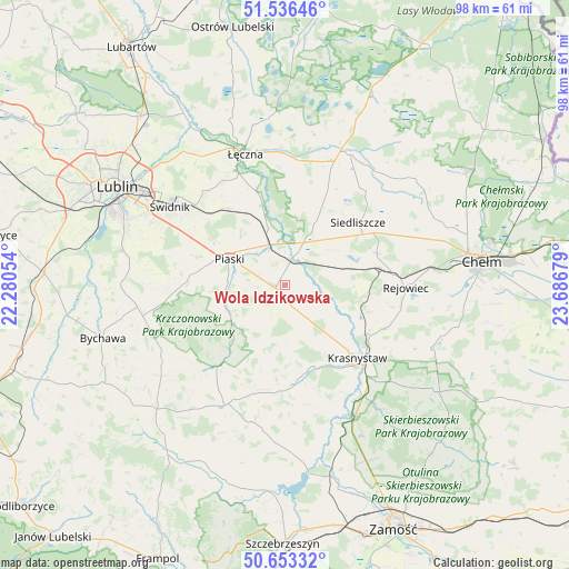
Wola Idzikowska GPS coordinates[2]
51° 5' 49.2" North, 22° 59' 1.176" East
| Map corner | latitude | longitude |
|---|---|---|
| Upper-left | 51.53646°, | 22.28054° |
| Center: | 51.097°, | 22.98366° |
| Lower-right: | 50.65332°, | 23.68679° |
| Map W x H: | 98.2×98.2 km | = 61×61mi |
| max Lat: | 54.83135° ⇑52.6% North |
| Wola Idzikowska: | 51.097° |
| min Lat: | ⇓47.4% South 49.21328° |
| min Long | Wola Idzikowska | max Long |
| 14.20249° | 22.98366° | 24.03723° |
| W 96.1%⇐ | ⇒3.9% E |
Elevation
Elevation of Wola Idzikowska is 194 m = 636 ft, and this is 2.6 m = 9 ft above average elevation for this country.
| Max E: |
974 m = 3196 ft | 41.7% |
| Wola Idzikowska | 194 m 636 ft | |
| Avg. | 191.4 m = 628 ft | |
Min E: |
-3 m = -10 ft | 58.3% |
See also: Poland elevation on elevation.city.
Geographical zone
Wola Idzikowska is located in North temperate zone (between Tropic of Cancer and the Arctic Circle). Distance of this North polar circle is 1719.7 km =1068.6 mi to North.| Distance of | km | miles | from Wola Idzikowska |
|---|---|---|---|
| North Pole | 4325.6 | 2687.8 | to North |
| Arctic Circle | 1719.7 | 1068.6 | to North |
| Tropic Cancer | 3075.5 | 1911 | to South |
| Equator | 5681.5 | 3530.3 | to South |


Nearby cities:
15 places around Wola Idzikowska: (largest is in red/bold)
• Fajsławice
1.4 km =0.9 mi,  265°
265°
• Gorzków
16.7 km =10.4 mi,  173°
173°
• Krasne
15 km =9.3 mi,  74°
74°
• Krasnystaw
18.3 km =11.4 mi,  133°
133°
• Mełgiew
19.9 km =12.4 mi,  315°
315°
• Milejów
15.6 km =9.7 mi,  344°
344°
• Olszanka
7.6 km =4.7 mi,  160°
160°
• Pawłów
16.9 km =10.5 mi, 70°
• Piaski
10.5 km =6.5 mi,  296°
296°
• Rejowiec
20.8 km =12.9 mi,  91°
91°
• Rejowiec Fabryczny
18.5 km =11.5 mi,  84°
84°
• Rybczewice
12 km =7.5 mi,  230°
230°
• Siedliszcze
16.6 km =10.3 mi,  49°
49°
• Trawniki
4.5 km =2.8 mi,  13°
13°
• Łopiennik Górny
6.7 km =4.2 mi, 158°
Sources, notices
• [Note1] Compared only with cities in Poland existing in our database
• [Src1] Map data: © OpenStreetMap contributors (CC-BY-SA)
• [Src2] Other city data from geonames.org with taken over terms of usage.
• [Src3] Geographical zone / Annual Mean Temperature by Robert A. Rohde @ Wikipedia
