Rybczewice geodata
Rybczewice (Lublin) is a seat of a third-order administrative division; located in Poland in Europe/Warsaw (GMT+2) time zone. With population of 840 people, there are 2782 cities with bigger population in this country. Compared to other cities in Poland, 54.6% of cities are located further ↑North; 94.9% of cities are located further ←West and 65.9% of cities have lower elevation than Rybczewice. Note1


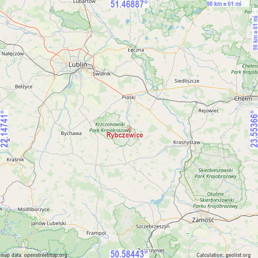
Rybczewice GPS coordinates[2]
51° 1' 43.536" North, 22° 51' 1.908" East
| Map corner | latitude | longitude |
|---|---|---|
| Upper-left | 51.46887°, | 22.14741° |
| Center: | 51.02876°, | 22.85053° |
| Lower-right: | 50.58443°, | 23.55366° |
| Map W x H: | 98.3×98.3 km | = 61.1×61.1mi |
| max Lat: | 54.83135° ⇑54.6% North |
| Rybczewice: | 51.02876° |
| min Lat: | ⇓45.4% South 49.21328° |
| min Long | Rybczewice | max Long |
| 14.20249° | 22.85053° | 24.03723° |
| W 94.9%⇐ | ⇒5.1% E |
Elevation
Elevation of Rybczewice is 216 m = 709 ft, and this is 24.6 m = 81 ft above average elevation for this country.
| Max E: |
974 m = 3196 ft | 34.1% |
| Rybczewice | 216 m 709 ft | |
| Avg. | 191.4 m = 628 ft | |
Min E: |
-3 m = -10 ft | 65.9% |
See also: Poland elevation on elevation.city.
Geographical zone
Rybczewice is located in North temperate zone (between Tropic of Cancer and the Arctic Circle). Distance of this North polar circle is 1727.3 km =1073.3 mi to North.| Distance of | km | miles | from Rybczewice |
|---|---|---|---|
| North Pole | 4333.2 | 2692.5 | to North |
| Arctic Circle | 1727.3 | 1073.3 | to North |
| Tropic Cancer | 3067.9 | 1906.3 | to South |
| Equator | 5673.9 | 3525.6 | to South |


Nearby cities:
15 places around Rybczewice: (largest is in red/bold)
• Bychawa
22.3 km =13.9 mi,  266°
266°
• Fajsławice
10.9 km =6.8 mi,  46°
46°
• Gorzków
14.5 km =9 mi,  128°
128°
• Jabłonna
19.2 km =11.9 mi,  290°
290°
• Krzczonów
10 km =6.2 mi,  256°
256°
• Mełgiew
22.3 km =13.9 mi,  348°
348°
• Olszanka
11.8 km =7.3 mi,  88°
88°
• Piaski
12.2 km =7.6 mi,  359°
359°
• Rudnik
18.6 km =11.6 mi,  152°
152°
• Trawniki
15.8 km =9.8 mi,  40°
40°
• Wola Idzikowska
12 km =7.5 mi, 50°
• Wysokie
18.4 km =11.4 mi,  224°
224°
• Łopiennik Górny
11.8 km =7.3 mi,  83°
83°
• Żabno
20.2 km =12.6 mi,  195°
195°
• Żółkiewka
13.3 km =8.3 mi,  184°
184°
Sources, notices
• [Note1] Compared only with cities in Poland existing in our database
• [Src1] Map data: © OpenStreetMap contributors (CC-BY-SA)
• [Src2] Other city data from geonames.org with taken over terms of usage.
• [Src3] Geographical zone / Annual Mean Temperature by Robert A. Rohde @ Wikipedia
