Fajsławice geodata
Fajsławice (Lublin) is a seat of a third-order administrative division; located in Poland in Europe/Warsaw (GMT+2) time zone. With population of 1,457 people, there are 1907 cities with bigger population in this country. Compared to other cities in Poland, 52.6% of cities are located further ↑North; 95.9% of cities are located further ←West and 56% of cities have lower elevation than Fajsławice. Note1


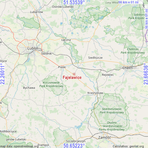
Fajsławice GPS coordinates[2]
51° 5' 45.312" North, 22° 57' 47.628" East
| Map corner | latitude | longitude |
|---|---|---|
| Upper-left | 51.53539°, | 22.26011° |
| Center: | 51.09592°, | 22.96323° |
| Lower-right: | 50.65223°, | 23.66636° |
| Map W x H: | 98.2×98.2 km | = 61×61mi |
| max Lat: | 54.83135° ⇑52.6% North |
| Fajsławice: | 51.09592° |
| min Lat: | ⇓47.4% South 49.21328° |
| min Long | Fajsławice | max Long |
| 14.20249° | 22.96323° | 24.03723° |
| W 95.9%⇐ | ⇒4.1% E |
Elevation
Elevation of Fajsławice is 188 m = 617 ft, and this is 3.4 m = 11 ft below average elevation for this country.
| Max E: |
974 m = 3196 ft | 44% |
| Avg. | 191.4 m = 628 ft | |
| Fajsławice | 188 m = 617 ft | |
Min E: |
-3 m = -10 ft | 56% |
See also: Poland elevation on elevation.city.
Geographical zone
Fajsławice is located in North temperate zone (between Tropic of Cancer and the Arctic Circle). Distance of this North polar circle is 1719.8 km =1068.6 mi to North.| Distance of | km | miles | from Fajsławice |
|---|---|---|---|
| North Pole | 4325.7 | 2687.9 | to North |
| Arctic Circle | 1719.8 | 1068.6 | to North |
| Tropic Cancer | 3075.4 | 1911 | to South |
| Equator | 5681.3 | 3530.2 | to South |


Nearby cities:
15 places around Fajsławice: (largest is in red/bold)
• Gorzków
16.8 km =10.4 mi,  168°
168°
• Krasne
16.4 km =10.2 mi,  75°
75°
• Krasnystaw
19.3 km =12 mi,  129°
129°
• Krzczonów
20.2 km =12.6 mi,  240°
240°
• Mełgiew
19 km =11.8 mi,  319°
319°
• Milejów
15.4 km =9.6 mi,  349°
349°
• Olszanka
8.1 km =5 mi,  150°
150°
• Pawłów
18.3 km =11.4 mi,  71°
71°
• Piaski
9.3 km =5.8 mi,  300°
300°
• Rejowiec Fabryczny
19.9 km =12.4 mi, 84°
• Rybczewice
10.9 km =6.8 mi,  226°
226°
• Siedliszcze
17.8 km =11.1 mi,  51°
51°
• Trawniki
5.1 km =3.2 mi,  28°
28°
• Wola Idzikowska
1.4 km =0.9 mi,  85°
85°
• Łopiennik Górny
7.2 km =4.5 mi, 147°
Sources, notices
• [Note1] Compared only with cities in Poland existing in our database
• [Src1] Map data: © OpenStreetMap contributors (CC-BY-SA)
• [Src2] Other city data from geonames.org with taken over terms of usage.
• [Src3] Geographical zone / Annual Mean Temperature by Robert A. Rohde @ Wikipedia
