Piaski geodata
Piaski (Lublin) is a seat of a third-order administrative division; located in Poland in Europe/Warsaw (GMT+2) time zone. With population of 2,634 people, there are 1195 cities with bigger population in this country. Compared to other cities in Poland, 51% of cities are located further ↑North; 94.8% of cities are located further ←West and 56.5% of cities have lower elevation than Piaski. Note1


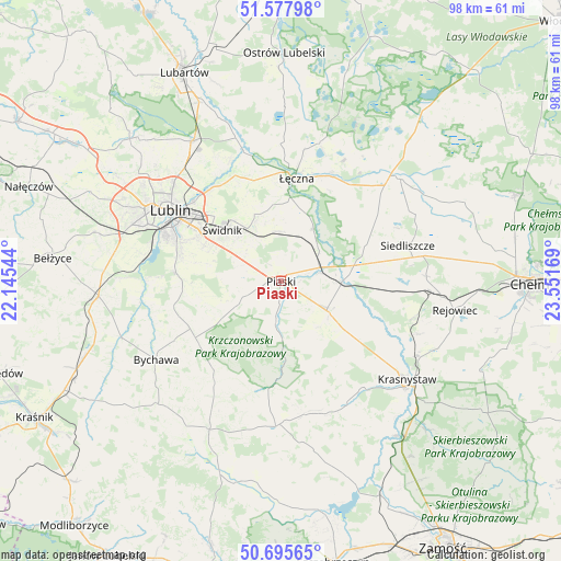
Piaski GPS coordinates[2]
51° 8' 20.112" North, 22° 50' 54.816" East
| Map corner | latitude | longitude |
|---|---|---|
| Upper-left | 51.57798°, | 22.14544° |
| Center: | 51.13892°, | 22.84856° |
| Lower-right: | 50.69565°, | 23.55169° |
| Map W x H: | 98.1×98.1 km | = 61×61mi |
| max Lat: | 54.83135° ⇑51% North |
| Piaski: | 51.13892° |
| min Lat: | ⇓49% South 49.21328° |
| min Long | Piaski | max Long |
| 14.20249° | 22.84856° | 24.03723° |
| W 94.8%⇐ | ⇒5.2% E |
Elevation
Elevation of Piaski is 189 m = 620 ft, and this is 2.4 m = 8 ft below average elevation for this country.
| Max E: |
974 m = 3196 ft | 43.5% |
| Avg. | 191.4 m = 628 ft | |
| Piaski | 189 m = 620 ft | |
Min E: |
-3 m = -10 ft | 56.5% |
See also: Poland elevation on elevation.city.
Geographical zone
Piaski is located in North temperate zone (between Tropic of Cancer and the Arctic Circle). Distance of this North polar circle is 1715.1 km =1065.7 mi to North.| Distance of | km | miles | from Piaski |
|---|---|---|---|
| North Pole | 4320.9 | 2684.9 | to North |
| Arctic Circle | 1715.1 | 1065.7 | to North |
| Tropic Cancer | 3080.2 | 1913.9 | to South |
| Equator | 5686.1 | 3533.2 | to South |


Nearby cities:
15 places around Piaski: (largest is in red/bold)
• Fajsławice
9.3 km =5.8 mi,  120°
120°
• Jabłonna
18.6 km =11.6 mi,  252°
252°
• Jakubowice Murowane
20.9 km =13 mi,  314°
314°
• Krzczonów
17.5 km =10.9 mi,  213°
213°
• Mełgiew
10.6 km =6.6 mi,  334°
334°
• Milejów
11.6 km =7.2 mi,  26°
26°
• Olszanka
16.8 km =10.4 mi,  134°
134°
• Puchaczów
21 km =13 mi,  24°
24°
• Rybczewice
12.2 km =7.6 mi,  179°
179°
• Trawniki
10.4 km =6.5 mi,  91°
91°
• Wola Idzikowska
10.5 km =6.5 mi, 116°
• Wólka
20.3 km =12.6 mi, 313°
• Łopiennik Górny
16.1 km =10 mi, 132°
• Łęczna
18.2 km =11.3 mi,  7°
7°
• Świdnik
13.9 km =8.6 mi, 309°
Sources, notices
• [Note1] Compared only with cities in Poland existing in our database
• [Src1] Map data: © OpenStreetMap contributors (CC-BY-SA)
• [Src2] Other city data from geonames.org with taken over terms of usage.
• [Src3] Geographical zone / Annual Mean Temperature by Robert A. Rohde @ Wikipedia
