Rejowiec Fabryczny geodata
Rejowiec Fabryczny (Lublin) is a seat of a third-order administrative division; located in Poland in Europe/Warsaw (GMT+2) time zone. With population of 4,474 people, there are 739 cities with bigger population in this country. Compared to other cities in Poland, 52.1% of cities are located further ↑North; 97.7% of cities are located further ←West and 60% of cities have lower elevation than Rejowiec Fabryczny. Note1


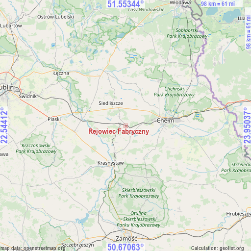
Rejowiec Fabryczny GPS coordinates[2]
51° 6' 50.904" North, 23° 14' 50.064" East
| Map corner | latitude | longitude |
|---|---|---|
| Upper-left | 51.55344°, | 22.54412° |
| Center: | 51.11414°, | 23.24724° |
| Lower-right: | 50.67063°, | 23.95037° |
| Map W x H: | 98.2×98.2 km | = 61×61mi |
| max Lat: | 54.83135° ⇑52.1% North |
| Rejowiec Fabryczny: | 51.11414° |
| min Lat: | ⇓47.9% South 49.21328° |
| min Long | Rejowiec Fabryc | max Long |
| 14.20249° | 23.24724° | 24.03723° |
| W 97.7%⇐ | ⇒2.3% E |
Elevation
Elevation of Rejowiec Fabryczny is 200 m = 656 ft, and this is 8.6 m = 28 ft above average elevation for this country.
| Max E: |
974 m = 3196 ft | 40% |
| Rejowiec Fabryczny | 200 m 656 ft | |
| Avg. | 191.4 m = 628 ft | |
Min E: |
-3 m = -10 ft | 60% |
See also: Poland elevation on elevation.city.
Geographical zone
Rejowiec Fabryczny is located in North temperate zone (between Tropic of Cancer and the Arctic Circle). Distance of this North polar circle is 1717.8 km =1067.4 mi to North.| Distance of | km | miles | from Rejowiec Fabryczny |
|---|---|---|---|
| North Pole | 4323.7 | 2686.6 | to North |
| Arctic Circle | 1717.8 | 1067.4 | to North |
| Tropic Cancer | 3077.4 | 1912.2 | to South |
| Equator | 5683.4 | 3531.5 | to South |


Nearby cities:
15 places around Rejowiec Fabryczny: (largest is in red/bold)
• Chełm
16 km =9.9 mi,  78°
78°
• Cyców
21.9 km =13.6 mi,  340°
340°
• Fajsławice
19.9 km =12.4 mi,  264°
264°
• Krasne
4.5 km =2.8 mi,  298°
298°
• Krasnystaw
15.3 km =9.5 mi,  199°
199°
• Kraśniczyn
21.5 km =13.4 mi,  160°
160°
• Olszanka
18.3 km =11.4 mi,  240°
240°
• Pawłów
4.4 km =2.7 mi,  325°
325°
• Pokrówka
15.2 km =9.4 mi,  98°
98°
• Rejowiec
3.5 km =2.2 mi,  136°
136°
• Siedliszcze
10.7 km =6.6 mi, 327°
• Siennica Różana
13.6 km =8.5 mi, 157°
• Trawniki
17.6 km =10.9 mi,  278°
278°
• Wola Idzikowska
18.5 km =11.5 mi, 264°
• Łopiennik Górny
18 km =11.2 mi, 242°
Sources, notices
• [Note1] Compared only with cities in Poland existing in our database
• [Src1] Map data: © OpenStreetMap contributors (CC-BY-SA)
• [Src2] Other city data from geonames.org with taken over terms of usage.
• [Src3] Geographical zone / Annual Mean Temperature by Robert A. Rohde @ Wikipedia
