Rejowiec geodata
Rejowiec (Lublin) is a populated place; located in Poland in Europe/Warsaw (GMT+2) time zone. With population of 2,114 people, there are 1405 cities with bigger population in this country. Compared to other cities in Poland, 52.9% of cities are located further ↑North; 97.8% of cities are located further ←West and 59.4% of cities have lower elevation than Rejowiec. Note1


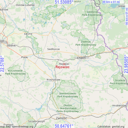
Rejowiec GPS coordinates[2]
51° 5' 28.824" North, 23° 16' 54.912" East
| Map corner | latitude | longitude |
|---|---|---|
| Upper-left | 51.53085°, | 22.5788° |
| Center: | 51.09134°, | 23.28192° |
| Lower-right: | 50.64761°, | 23.98505° |
| Map W x H: | 98.2×98.2 km | = 61×61mi |
| max Lat: | 54.83135° ⇑52.9% North |
| Rejowiec: | 51.09134° |
| min Lat: | ⇓47.1% South 49.21328° |
| min Long | Rejowiec | max Long |
| 14.20249° | 23.28192° | 24.03723° |
| W 97.8%⇐ | ⇒2.2% E |
Elevation
Elevation of Rejowiec is 199 m = 653 ft, and this is 7.6 m = 25 ft above average elevation for this country.
| Max E: |
974 m = 3196 ft | 40.6% |
| Rejowiec | 199 m 653 ft | |
| Avg. | 191.4 m = 628 ft | |
Min E: |
-3 m = -10 ft | 59.4% |
See also: Poland elevation on elevation.city.
Geographical zone
Rejowiec is located in North temperate zone (between Tropic of Cancer and the Arctic Circle). Distance of this North polar circle is 1720.3 km =1068.9 mi to North.| Distance of | km | miles | from Rejowiec |
|---|---|---|---|
| North Pole | 4326.2 | 2688.2 | to North |
| Arctic Circle | 1720.3 | 1068.9 | to North |
| Tropic Cancer | 3074.9 | 1910.7 | to South |
| Equator | 5680.8 | 3529.9 | to South |


Nearby cities:
15 places around Rejowiec: (largest is in red/bold)
• Chełm
14.4 km =8.9 mi,  66°
66°
• Fajsławice
22.3 km =13.9 mi,  271°
271°
• Kamień
21.2 km =13.2 mi,  88°
88°
• Krasne
7.9 km =4.9 mi,  306°
306°
• Krasnystaw
14.1 km =8.8 mi,  212°
212°
• Kraśniczyn
18.4 km =11.4 mi,  165°
165°
• Olszanka
19.5 km =12.1 mi,  250°
250°
• Pawłów
7.9 km =4.9 mi,  321°
321°
• Pokrówka
12.7 km =7.9 mi, 88°
• Rejowiec Fabryczny
3.5 km =2.2 mi, 316°
• Siedliszcze
14.1 km =8.8 mi, 324°
• Siennica Różana
10.4 km =6.5 mi,  164°
164°
• Trawniki
20.4 km =12.7 mi,  284°
284°
• Wola Idzikowska
20.8 km =12.9 mi, 271°
• Łopiennik Górny
19.3 km =12 mi, 253°
Sources, notices
• [Note1] Compared only with cities in Poland existing in our database
• [Src1] Map data: © OpenStreetMap contributors (CC-BY-SA)
• [Src2] Other city data from geonames.org with taken over terms of usage.
• [Src3] Geographical zone / Annual Mean Temperature by Robert A. Rohde @ Wikipedia
