Wojnicz geodata
Wojnicz (Lesser Poland) is a seat of a third-order administrative division; located in Poland in Europe/Warsaw (GMT+2) time zone. With population of 3,509 people, there are 908 cities with bigger population in this country. Compared to other cities in Poland, 85% of cities are located further ↑North; 69.7% of cities are located further ←West and 61% of cities have lower elevation than Wojnicz. Note1


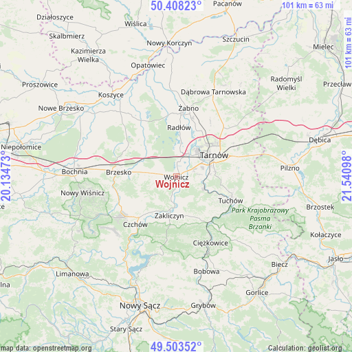
Wojnicz GPS coordinates[2]
49° 57' 28.8" North, 20° 50' 16.26" East
| Map corner | latitude | longitude |
|---|---|---|
| Upper-left | 50.40823°, | 20.13473° |
| Center: | 49.958°, | 20.83785° |
| Lower-right: | 49.50352°, | 21.54098° |
| Map W x H: | 100.6×100.6 km | = 62.5×62.5mi |
| max Lat: | 54.83135° ⇑85% North |
| Wojnicz: | 49.958° |
| min Lat: | ⇓15% South 49.21328° |
| min Long | Wojnicz | max Long |
| 14.20249° | 20.83785° | 24.03723° |
| W 69.7%⇐ | ⇒30.3% E |
Elevation
Elevation of Wojnicz is 203 m = 666 ft, and this is 11.6 m = 38 ft above average elevation for this country.
| Max E: |
974 m = 3196 ft | 39% |
| Wojnicz | 203 m 666 ft | |
| Avg. | 191.4 m = 628 ft | |
Min E: |
-3 m = -10 ft | 61% |
See also: Poland elevation on elevation.city.
Geographical zone
Wojnicz is located in North temperate zone (between Tropic of Cancer and the Arctic Circle). Distance of this North polar circle is 1846.4 km =1147.3 mi to North.| Distance of | km | miles | from Wojnicz |
|---|---|---|---|
| North Pole | 4452.3 | 2766.5 | to North |
| Arctic Circle | 1846.4 | 1147.3 | to North |
| Tropic Cancer | 2948.9 | 1832.4 | to South |
| Equator | 5554.8 | 3451.6 | to South |


Nearby cities:
15 places around Wojnicz: (largest is in red/bold)
• Bogumiłowice
5.9 km =3.7 mi,  20°
20°
• Błonie
4.7 km =2.9 mi,  98°
98°
• Dębno
8.5 km =5.3 mi,  276°
276°
• Gwoździec
9.2 km =5.7 mi,  217°
217°
• Janowice
7.6 km =4.7 mi,  167°
167°
• Jaworsko
8.5 km =5.3 mi,  227°
227°
• Koszyce
7.6 km =4.7 mi,  77°
77°
• Koszyce Wielkie
8.1 km =5 mi,  71°
71°
• Olszyny
7.4 km =4.6 mi,  190°
190°
• Pleśna
8.5 km =5.3 mi,  114°
114°
• Porąbka Uszewska
10.7 km =6.6 mi,  260°
260°
• Rychwałd
9.2 km =5.7 mi,  128°
128°
• Wielka Wieś
2.6 km =1.6 mi,  203°
203°
• Wierzchosławice
7.5 km =4.7 mi,  10°
10°
• Wróblowice
9.1 km =5.7 mi, 172°
Sources, notices
• [Note1] Compared only with cities in Poland existing in our database
• [Src1] Map data: © OpenStreetMap contributors (CC-BY-SA)
• [Src2] Other city data from geonames.org with taken over terms of usage.
• [Src3] Geographical zone / Annual Mean Temperature by Robert A. Rohde @ Wikipedia
