Wierzchosławice geodata
Wierzchosławice (Lesser Poland) is a seat of a third-order administrative division; located in Poland in Europe/Warsaw (GMT+2) time zone. With population of 3,000 people, there are 1040 cities with bigger population in this country. Compared to other cities in Poland, 81.1% of cities are located further ↑North; 70.1% of cities are located further ←West and 57.7% of cities have lower elevation than Wierzchosławice. Note1
Administrative division(s):
- Level 1: Lesser Poland
- Level 2: Powiat tarnowski
- Level 3: Wierzchosławice


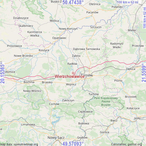
Wierzchosławice GPS coordinates[2]
50° 1' 29.208" North, 20° 51' 24.372" East
| Map corner | latitude | longitude |
|---|---|---|
| Upper-left | 50.47438°, | 20.15365° |
| Center: | 50.02478°, | 20.85677° |
| Lower-right: | 49.57093°, | 21.5599° |
| Map W x H: | 100.5×100.5 km | = 62.4×62.4mi |
| max Lat: | 54.83135° ⇑81.1% North |
| Wierzchosławice: | 50.02478° |
| min Lat: | ⇓18.9% South 49.21328° |
| min Long | Wierzchosławic | max Long |
| 14.20249° | 20.85677° | 24.03723° |
| W 70.1%⇐ | ⇒29.9% E |
Elevation
Elevation of Wierzchosławice is 193 m = 633 ft, and this is 1.6 m = 5 ft above average elevation for this country.
| Max E: |
974 m = 3196 ft | 42.3% |
| Wierzchosławice | 193 m 633 ft | |
| Avg. | 191.4 m = 628 ft | |
Min E: |
-3 m = -10 ft | 57.7% |
See also: Poland elevation on elevation.city.
Geographical zone
Wierzchosławice is located in North temperate zone (between Tropic of Cancer and the Arctic Circle). Distance of this North polar circle is 1838.9 km =1142.6 mi to North.| Distance of | km | miles | from Wierzchosławice |
|---|---|---|---|
| North Pole | 4444.8 | 2761.9 | to North |
| Arctic Circle | 1838.9 | 1142.6 | to North |
| Tropic Cancer | 2956.3 | 1837 | to South |
| Equator | 5562.2 | 3456.2 | to South |


Nearby cities:
15 places around Wierzchosławice: (largest is in red/bold)
• Biskupice Radłowskie
10.7 km =6.6 mi,  1°
1°
• Bogumiłowice
2.1 km =1.3 mi,  159°
159°
• Borzęcin
11.3 km =7 mi,  293°
293°
• Błonie
8.7 km =5.4 mi, 157°
• Koszyce
8.4 km =5.2 mi,  133°
133°
• Koszyce Wielkie
8 km =5 mi, 127°
• Niedomice
9.6 km =6 mi,  16°
16°
• Radłów
6.6 km =4.1 mi,  355°
355°
• Tarnowiec
10.4 km =6.5 mi,  117°
117°
• Tarnów
9.4 km =5.8 mi,  97°
97°
• Wielka Wieś
10.1 km =6.3 mi,  193°
193°
• Wojnicz
7.5 km =4.7 mi, 190°
• Wokowice
11.4 km =7.1 mi,  259°
259°
• Zabawa
10.9 km =6.8 mi,  347°
347°
• Łukowa
11.4 km =7.1 mi,  48°
48°
Sources, notices
• [Note1] Compared only with cities in Poland existing in our database
• [Src1] Map data: © OpenStreetMap contributors (CC-BY-SA)
• [Src2] Other city data from geonames.org with taken over terms of usage.
• [Src3] Geographical zone / Annual Mean Temperature by Robert A. Rohde @ Wikipedia
