Dębno geodata
Dębno (Lesser Poland) is a seat of a third-order administrative division; located in Poland in Europe/Warsaw (GMT+2) time zone. With population of 1,601 people, there are 1750 cities with bigger population in this country. Compared to other cities in Poland, 84.5% of cities are located further ↑North; 68% of cities are located further ←West and 67.4% of cities have lower elevation than Dębno. Note1


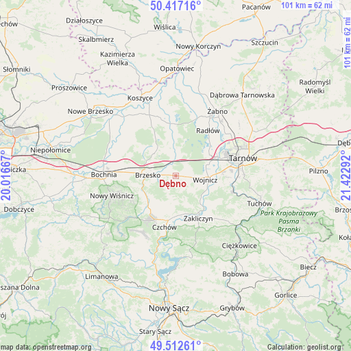
Dębno GPS coordinates[2]
49° 58' 1.236" North, 20° 43' 11.244" East
| Map corner | latitude | longitude |
|---|---|---|
| Upper-left | 50.41716°, | 20.01667° |
| Center: | 49.96701°, | 20.71979° |
| Lower-right: | 49.51261°, | 21.42292° |
| Map W x H: | 100.6×100.6 km | = 62.5×62.5mi |
| max Lat: | 54.83135° ⇑84.5% North |
| Dębno: | 49.96701° |
| min Lat: | ⇓15.5% South 49.21328° |
| min Long | Dębno | max Long |
| 14.20249° | 20.71979° | 24.03723° |
| W 68%⇐ | ⇒32% E |
Elevation
Elevation of Dębno is 221 m = 725 ft, and this is 29.6 m = 97 ft above average elevation for this country.
| Max E: |
974 m = 3196 ft | 32.6% |
| Dębno | 221 m 725 ft | |
| Avg. | 191.4 m = 628 ft | |
Min E: |
-3 m = -10 ft | 67.4% |
See also: Poland elevation on elevation.city.
Geographical zone
Dębno is located in North temperate zone (between Tropic of Cancer and the Arctic Circle). Distance of this North polar circle is 1845.4 km =1146.7 mi to North.| Distance of | km | miles | from Dębno |
|---|---|---|---|
| North Pole | 4451.3 | 2765.9 | to North |
| Arctic Circle | 1845.4 | 1146.7 | to North |
| Tropic Cancer | 2949.9 | 1833 | to South |
| Equator | 5555.8 | 3452.2 | to South |


Nearby cities:
15 places around Dębno: (largest is in red/bold)
• Brzesko
8.1 km =5 mi,  271°
271°
• Jadowniki
5.5 km =3.4 mi,  260°
260°
• Jaworsko
7.1 km =4.4 mi,  162°
162°
• Maszkienice
3.4 km =2.1 mi,  316°
316°
• Niedźwiedza
7.8 km =4.8 mi,  181°
181°
• Okocim
8.7 km =5.4 mi, 256°
• Porąbka Uszewska
3.4 km =2.1 mi,  217°
217°
• Przyborów
8.1 km =5 mi,  329°
329°
• Sterkowiec
4.2 km =2.6 mi, 318°
• Szczepanów
6.3 km =3.9 mi,  312°
312°
• Wielka Wieś
8.1 km =5 mi,  114°
114°
• Wojnicz
8.5 km =5.3 mi,  96°
96°
• Wokowice
4.6 km =2.9 mi,  342°
342°
• Wola Dębińska
2.8 km =1.7 mi, 306°
• Łoniowa
5.9 km =3.7 mi,  198°
198°
Sources, notices
• [Note1] Compared only with cities in Poland existing in our database
• [Src1] Map data: © OpenStreetMap contributors (CC-BY-SA)
• [Src2] Other city data from geonames.org with taken over terms of usage.
• [Src3] Geographical zone / Annual Mean Temperature by Robert A. Rohde @ Wikipedia
