Pleśna geodata
Pleśna (Lesser Poland) is a seat of a third-order administrative division; located in Poland in Europe/Warsaw (GMT+2) time zone. With population of 1,890 people, there are 1568 cities with bigger population in this country. Compared to other cities in Poland, 86.5% of cities are located further ↑North; 71.4% of cities are located further ←West and 65.9% of cities have lower elevation than Pleśna. Note1


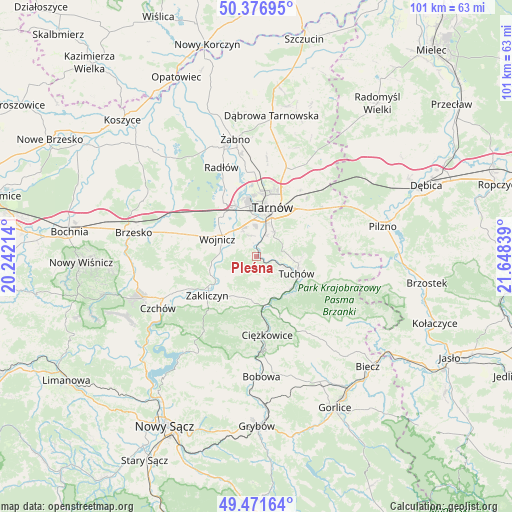
Pleśna GPS coordinates[2]
49° 55' 35.112" North, 20° 56' 42.936" East
| Map corner | latitude | longitude |
|---|---|---|
| Upper-left | 50.37695°, | 20.24214° |
| Center: | 49.92642°, | 20.94526° |
| Lower-right: | 49.47164°, | 21.64839° |
| Map W x H: | 100.7×100.7 km | = 62.6×62.6mi |
| max Lat: | 54.83135° ⇑86.5% North |
| Pleśna: | 49.92642° |
| min Lat: | ⇓13.5% South 49.21328° |
| min Long | Pleśna | max Long |
| 14.20249° | 20.94526° | 24.03723° |
| W 71.4%⇐ | ⇒28.6% E |
Elevation
Elevation of Pleśna is 216 m = 709 ft, and this is 24.6 m = 81 ft above average elevation for this country.
| Max E: |
974 m = 3196 ft | 34.1% |
| Pleśna | 216 m 709 ft | |
| Avg. | 191.4 m = 628 ft | |
Min E: |
-3 m = -10 ft | 65.9% |
See also: Poland elevation on elevation.city.
Geographical zone
Pleśna is located in North temperate zone (between Tropic of Cancer and the Arctic Circle). Distance of this North polar circle is 1849.9 km =1149.5 mi to North.| Distance of | km | miles | from Pleśna |
|---|---|---|---|
| North Pole | 4455.8 | 2768.7 | to North |
| Arctic Circle | 1849.9 | 1149.5 | to North |
| Tropic Cancer | 2945.4 | 1830.2 | to South |
| Equator | 5551.3 | 3449.4 | to South |


Nearby cities:
15 places around Pleśna: (largest is in red/bold)
• Błonie
4.1 km =2.5 mi,  313°
313°
• Janowice
7.2 km =4.5 mi,  237°
237°
• Karwodrza
9.2 km =5.7 mi,  90°
90°
• Koszyce
5.1 km =3.2 mi,  357°
357°
• Koszyce Wielkie
6 km =3.7 mi,  0°
0°
• Lubaszowa
9.9 km =6.2 mi,  138°
138°
• Olszyny
9.8 km =6.1 mi,  247°
247°
• Rychwałd
2.3 km =1.4 mi,  192°
192°
• Siedliska
7.1 km =4.4 mi,  149°
149°
• Siemiechów
8.6 km =5.3 mi,  199°
199°
• Tarnowiec
6.8 km =4.2 mi,  25°
25°
• Tuchów
8.5 km =5.3 mi,  114°
114°
• Wielka Wieś
8.8 km =5.5 mi,  277°
277°
• Wojnicz
8.5 km =5.3 mi,  294°
294°
• Wróblowice
8.5 km =5.3 mi,  229°
229°
Sources, notices
• [Note1] Compared only with cities in Poland existing in our database
• [Src1] Map data: © OpenStreetMap contributors (CC-BY-SA)
• [Src2] Other city data from geonames.org with taken over terms of usage.
• [Src3] Geographical zone / Annual Mean Temperature by Robert A. Rohde @ Wikipedia
