Wawer geodata
Wawer (Mazovia) is a populated place; located in Poland in Europe/Warsaw (GMT+2) time zone. With population of 62,656 people, there are 82 cities with bigger population in this country. Compared to other cities in Poland, 70% of cities are located further ↓South; 75.5% of cities are located further ←West and 82.2% of cities have higher elevation than Wawer. Note1


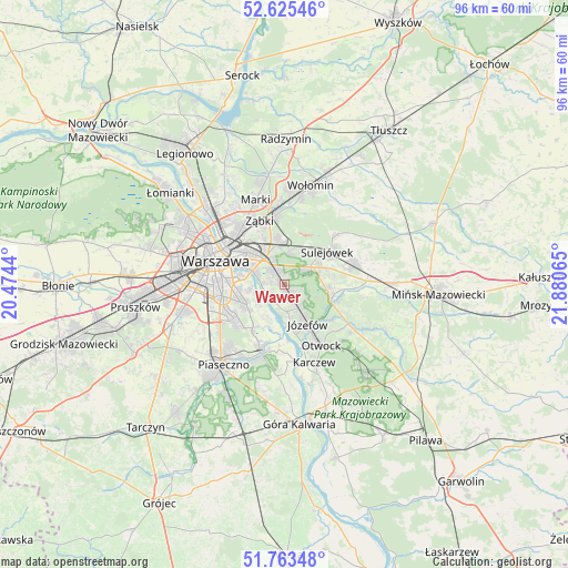
Wawer GPS coordinates[2]
52° 11' 47.616" North, 21° 10' 39.072" East
| Map corner | latitude | longitude |
|---|---|---|
| Upper-left | 52.62546°, | 20.4744° |
| Center: | 52.19656°, | 21.17752° |
| Lower-right: | 51.76348°, | 21.88065° |
| Map W x H: | 95.8×95.8 km | = 59.5×59.5mi |
| max Lat: | 54.83135° ⇑30% North |
| Wawer: | 52.19656° |
| min Lat: | ⇓70% South 49.21328° |
| min Long | Wawer | max Long |
| 14.20249° | 21.17752° | 24.03723° |
| W 75.5%⇐ | ⇒24.5% E |
Elevation
Elevation of Wawer is 95 m = 312 ft, and this is 96.4 m = 316 ft below average elevation for this country.
| Max E: |
974 m = 3196 ft | 82.2% |
| Avg. | 191.4 m = 628 ft | |
| Wawer | 95 m = 312 ft | |
Min E: |
-3 m = -10 ft | 17.8% |
See also: Wawer elevation on elevation.city.
Geographical zone
Wawer is located in North temperate zone (between Tropic of Cancer and the Arctic Circle). Distance of this North polar circle is 1597.5 km =992.6 mi to North.| Distance of | km | miles | from Wawer |
|---|---|---|---|
| North Pole | 4203.3 | 2611.8 | to North |
| Arctic Circle | 1597.5 | 992.6 | to North |
| Tropic Cancer | 3197.8 | 1987 | to South |
| Equator | 5803.7 | 3606.3 | to South |


Nearby cities:
15 places around Wawer: (largest is in red/bold)
• Bielawa
10.2 km =6.3 mi,  197°
197°
• Józefów
7.7 km =4.8 mi,  148°
148°
• Kabaty
9.9 km =6.2 mi,  221°
221°
• Mokotów
9.7 km =6 mi,  267°
267°
• Otwock
11.6 km =7.2 mi, 150°
• Praga Południe
8.2 km =5.1 mi,  310°
310°
• Praga Północ
11.7 km =7.3 mi,  303°
303°
• Rembertów
7.2 km =4.5 mi,  352°
352°
• Sulejówek
8.8 km =5.5 mi,  45°
45°
• Ursynów
10.1 km =6.3 mi,  239°
239°
• Wesoła
7.2 km =4.5 mi,  26°
26°
• Wilanów
7.2 km =4.5 mi, 238°
• Wiązowna
8.3 km =5.2 mi,  110°
110°
• Ząbki
11.8 km =7.3 mi,  335°
335°
• Śródmieście
11.6 km =7.2 mi,  288°
288°
Sources, notices
• [Note1] Compared only with cities in Poland existing in our database
• [Src1] Map data: © OpenStreetMap contributors (CC-BY-SA)
• [Src2] Other city data from geonames.org with taken over terms of usage.
• [Src3] Geographical zone / Annual Mean Temperature by Robert A. Rohde @ Wikipedia
