Wieliczka geodata
Wieliczka (Lesser Poland) is a seat of a second-order administrative division; located in Poland in Europe/Warsaw (GMT+2) time zone. With population of 18,677 people, there are 259 cities with bigger population in this country. Compared to other cities in Poland, 83.2% of cities are located further ↑North; 59.3% of cities are located further ←West and 79% of cities have lower elevation than Wieliczka. Note1


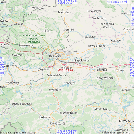
Wieliczka GPS coordinates[2]
49° 59' 14.568" North, 20° 3' 53.028" East
| Map corner | latitude | longitude |
|---|---|---|
| Upper-left | 50.43734°, | 19.36161° |
| Center: | 49.98738°, | 20.06473° |
| Lower-right: | 49.53317°, | 20.76786° |
| Map W x H: | 100.5×100.5 km | = 62.4×62.4mi |
| max Lat: | 54.83135° ⇑83.2% North |
| Wieliczka: | 49.98738° |
| min Lat: | ⇓16.8% South 49.21328° |
| min Long | Wieliczka | max Long |
| 14.20249° | 20.06473° | 24.03723° |
| W 59.3%⇐ | ⇒40.7% E |
Elevation
Elevation of Wieliczka is 261 m = 856 ft, and this is 69.6 m = 228 ft above average elevation for this country.
| Max E: |
974 m = 3196 ft | 21% |
| Wieliczka | 261 m 856 ft | |
| Avg. | 191.4 m = 628 ft | |
Min E: |
-3 m = -10 ft | 79% |
See also: Poland elevation on elevation.city.
Geographical zone
Wieliczka is located in North temperate zone (between Tropic of Cancer and the Arctic Circle). Distance of this North polar circle is 1843.1 km =1145.2 mi to North.| Distance of | km | miles | from Wieliczka |
|---|---|---|---|
| North Pole | 4449 | 2764.5 | to North |
| Arctic Circle | 1843.1 | 1145.2 | to North |
| Tropic Cancer | 2952.2 | 1834.4 | to South |
| Equator | 5558.1 | 3453.6 | to South |


Nearby cities:
15 places around Wieliczka: (largest is in red/bold)
• Biskupice
4.8 km =3 mi,  123°
123°
• Czarnochowice
1.9 km =1.2 mi,  6°
6°
• Kokotów
3 km =1.9 mi,  19°
19°
• Lusina
9.8 km =6.1 mi,  258°
258°
• Ochojno
7.5 km =4.7 mi,  239°
239°
• Pawlikowice
3.9 km =2.4 mi,  190°
190°
• Podłęże
8 km =5 mi,  67°
67°
• Rzeszotary
8 km =5 mi, 235°
• Tomaszkowice
2.7 km =1.7 mi,  110°
110°
• Trąbki
6.2 km =3.9 mi, 116°
• Wrząsowice
9 km =5.6 mi,  249°
249°
• Węgrzce Wielkie
4.5 km =2.8 mi,  47°
47°
• Zabawa
2.1 km =1.3 mi, 65°
• Śledziejowice
2.3 km =1.4 mi,  34°
34°
• Świątniki Górne
9.9 km =6.2 mi,  233°
233°
Sources, notices
• [Note1] Compared only with cities in Poland existing in our database
• [Src1] Map data: © OpenStreetMap contributors (CC-BY-SA)
• [Src2] Other city data from geonames.org with taken over terms of usage.
• [Src3] Geographical zone / Annual Mean Temperature by Robert A. Rohde @ Wikipedia
