Podłęże geodata
Podłęże (Lesser Poland) is a populated place; located in Poland in Europe/Warsaw (GMT+2) time zone. With population of 1,978 people, there are 1507 cities with bigger population in this country. Compared to other cities in Poland, 81.7% of cities are located further ↑North; 60.9% of cities are located further ←West and 61% of cities have lower elevation than Podłęże. Note1


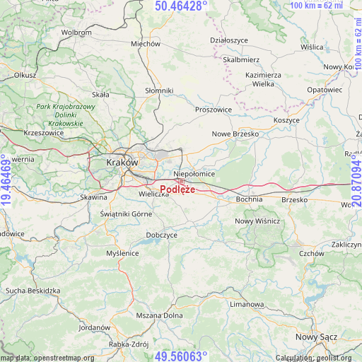
Podłęże GPS coordinates[2]
50° 0' 52.488" North, 20° 10' 4.116" East
| Map corner | latitude | longitude |
|---|---|---|
| Upper-left | 50.46428°, | 19.46469° |
| Center: | 50.01458°, | 20.16781° |
| Lower-right: | 49.56063°, | 20.87094° |
| Map W x H: | 100.5×100.5 km | = 62.4×62.4mi |
| max Lat: | 54.83135° ⇑81.7% North |
| Podłęże: | 50.01458° |
| min Lat: | ⇓18.3% South 49.21328° |
| min Long | Podłęże | max Long |
| 14.20249° | 20.16781° | 24.03723° |
| W 60.9%⇐ | ⇒39.1% E |
Elevation
Elevation of Podłęże is 203 m = 666 ft, and this is 11.6 m = 38 ft above average elevation for this country.
| Max E: |
974 m = 3196 ft | 39% |
| Podłęże | 203 m 666 ft | |
| Avg. | 191.4 m = 628 ft | |
Min E: |
-3 m = -10 ft | 61% |
See also: Poland elevation on elevation.city.
Geographical zone
Podłęże is located in North temperate zone (between Tropic of Cancer and the Arctic Circle). Distance of this North polar circle is 1840.1 km =1143.4 mi to North.| Distance of | km | miles | from Podłęże |
|---|---|---|---|
| North Pole | 4446 | 2762.6 | to North |
| Arctic Circle | 1840.1 | 1143.4 | to North |
| Tropic Cancer | 2955.2 | 1836.3 | to South |
| Equator | 5561.1 | 3455.5 | to South |


Nearby cities:
15 places around Podłęże: (largest is in red/bold)
• Biskupice
6.6 km =4.1 mi,  210°
210°
• Czarnochowice
7.2 km =4.5 mi,  261°
261°
• Dąbrowa
6.3 km =3.9 mi,  98°
98°
• Kokotów
6.4 km =4 mi,  267°
267°
• Niepołomice
4.9 km =3 mi,  53°
53°
• Szarów
7.6 km =4.7 mi,  106°
106°
• Szczytniki
6.3 km =3.9 mi,  135°
135°
• Targowisko
9.6 km =6 mi, 110°
• Tomaszkowice
6.3 km =3.9 mi,  231°
231°
• Trąbki
6.1 km =3.8 mi,  197°
197°
• Wieliczka
8 km =5 mi,  247°
247°
• Wola Batorska
8.2 km =5.1 mi,  58°
58°
• Węgrzce Wielkie
4.1 km =2.5 mi, 270°
• Zabawa
5.9 km =3.7 mi, 248°
• Śledziejowice
6.2 km =3.9 mi, 259°
Sources, notices
• [Note1] Compared only with cities in Poland existing in our database
• [Src1] Map data: © OpenStreetMap contributors (CC-BY-SA)
• [Src2] Other city data from geonames.org with taken over terms of usage.
• [Src3] Geographical zone / Annual Mean Temperature by Robert A. Rohde @ Wikipedia
