Pawlikowice geodata
Pawlikowice (Lesser Poland) is a populated place; located in Poland in Europe/Warsaw (GMT+2) time zone. With population of 1,200 people, there are 2164 cities with bigger population in this country. Compared to other cities in Poland, 85.2% of cities are located further ↑North; 59.2% of cities are located further ←West and 90.8% of cities have lower elevation than Pawlikowice. Note1


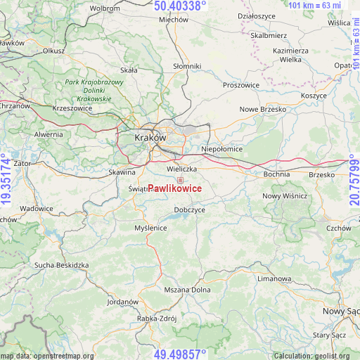
Pawlikowice GPS coordinates[2]
49° 57' 11.16" North, 20° 3' 17.496" East
| Map corner | latitude | longitude |
|---|---|---|
| Upper-left | 50.40338°, | 19.35174° |
| Center: | 49.9531°, | 20.05486° |
| Lower-right: | 49.49857°, | 20.75799° |
| Map W x H: | 100.6×100.6 km | = 62.5×62.5mi |
| max Lat: | 54.83135° ⇑85.2% North |
| Pawlikowice: | 49.9531° |
| min Lat: | ⇓14.8% South 49.21328° |
| min Long | Pawlikowice | max Long |
| 14.20249° | 20.05486° | 24.03723° |
| W 59.2%⇐ | ⇒40.8% E |
Elevation
Elevation of Pawlikowice is 341 m = 1119 ft, and this is 149.6 m = 491 ft above average elevation for this country.
| Max E: |
974 m = 3196 ft | 9.2% |
| Pawlikowice | 341 m 1119 ft | |
| Avg. | 191.4 m = 628 ft | |
Min E: |
-3 m = -10 ft | 90.8% |
See also: Poland elevation on elevation.city.
Geographical zone
Pawlikowice is located in North temperate zone (between Tropic of Cancer and the Arctic Circle). Distance of this North polar circle is 1846.9 km =1147.6 mi to North.| Distance of | km | miles | from Pawlikowice |
|---|---|---|---|
| North Pole | 4452.8 | 2766.8 | to North |
| Arctic Circle | 1846.9 | 1147.6 | to North |
| Tropic Cancer | 2948.3 | 1832 | to South |
| Equator | 5554.3 | 3451.3 | to South |


Nearby cities:
15 places around Pawlikowice: (largest is in red/bold)
• Biskupice
4.9 km =3 mi,  76°
76°
• Czarnochowice
5.8 km =3.6 mi,  9°
9°
• Dobczyce
8.4 km =5.2 mi,  162°
162°
• Kokotów
6.8 km =4.2 mi, 14°
• Ochojno
5.7 km =3.5 mi,  269°
269°
• Rzeszotary
5.9 km =3.7 mi,  262°
262°
• Siepraw
8.1 km =5 mi,  237°
237°
• Tomaszkowice
4.3 km =2.7 mi,  47°
47°
• Trąbki
6.3 km =3.9 mi, 80°
• Wieliczka
3.9 km =2.4 mi, 10°
• Wrząsowice
7.8 km =4.8 mi, 274°
• Węgrzce Wielkie
8 km =5 mi,  30°
30°
• Zabawa
5.3 km =3.3 mi, 29°
• Śledziejowice
6 km =3.7 mi,  19°
19°
• Świątniki Górne
7.5 km =4.7 mi,  253°
253°
Sources, notices
• [Note1] Compared only with cities in Poland existing in our database
• [Src1] Map data: © OpenStreetMap contributors (CC-BY-SA)
• [Src2] Other city data from geonames.org with taken over terms of usage.
• [Src3] Geographical zone / Annual Mean Temperature by Robert A. Rohde @ Wikipedia
