Trąbki geodata
Trąbki (Lesser Poland) is a populated place; located in Poland in Europe/Warsaw (GMT+2) time zone. With population of 1,200 people, there are 2164 cities with bigger population in this country. Compared to other cities in Poland, 84.8% of cities are located further ↑North; 60.7% of cities are located further ←West and 86.1% of cities have lower elevation than Trąbki. Note1


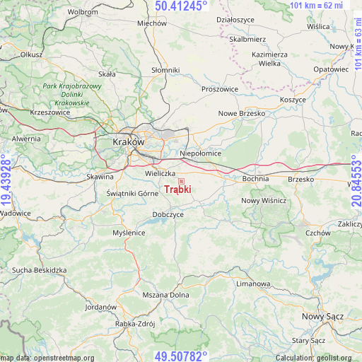
Trąbki GPS coordinates[2]
49° 57' 44.136" North, 20° 8' 32.64" East
| Map corner | latitude | longitude |
|---|---|---|
| Upper-left | 50.41245°, | 19.43928° |
| Center: | 49.96226°, | 20.1424° |
| Lower-right: | 49.50782°, | 20.84553° |
| Map W x H: | 100.6×100.6 km | = 62.5×62.5mi |
| max Lat: | 54.83135° ⇑84.8% North |
| Trąbki: | 49.96226° |
| min Lat: | ⇓15.2% South 49.21328° |
| min Long | Trąbki | max Long |
| 14.20249° | 20.1424° | 24.03723° |
| W 60.7%⇐ | ⇒39.3% E |
Elevation
Elevation of Trąbki is 296 m = 971 ft, and this is 104.6 m = 343 ft above average elevation for this country.
| Max E: |
974 m = 3196 ft | 13.9% |
| Trąbki | 296 m 971 ft | |
| Avg. | 191.4 m = 628 ft | |
Min E: |
-3 m = -10 ft | 86.1% |
See also: Poland elevation on elevation.city.
Geographical zone
Trąbki is located in North temperate zone (between Tropic of Cancer and the Arctic Circle). Distance of this North polar circle is 1845.9 km =1147 mi to North.| Distance of | km | miles | from Trąbki |
|---|---|---|---|
| North Pole | 4451.8 | 2766.2 | to North |
| Arctic Circle | 1845.9 | 1147 | to North |
| Tropic Cancer | 2949.4 | 1832.7 | to South |
| Equator | 5555.3 | 3451.9 | to South |


Nearby cities:
15 places around Trąbki: (largest is in red/bold)
• Biskupice
1.5 km =0.9 mi,  275°
275°
• Cichawa
9 km =5.6 mi,  97°
97°
• Czarnochowice
7.1 km =4.4 mi,  311°
311°
• Dąbrowa
9.4 km =5.8 mi,  58°
58°
• Gdów
7.2 km =4.5 mi,  146°
146°
• Kokotów
7.2 km =4.5 mi,  320°
320°
• Marszowice
8.4 km =5.2 mi,  126°
126°
• Pawlikowice
6.3 km =3.9 mi,  260°
260°
• Podłęże
6.1 km =3.8 mi,  17°
17°
• Szczytniki
6.4 km =4 mi,  77°
77°
• Tomaszkowice
3.6 km =2.2 mi,  301°
301°
• Wieliczka
6.2 km =3.9 mi, 296°
• Węgrzce Wielkie
6.3 km =3.9 mi,  338°
338°
• Zabawa
5.2 km =3.2 mi, 314°
• Śledziejowice
6.3 km =3.9 mi, 317°
Sources, notices
• [Note1] Compared only with cities in Poland existing in our database
• [Src1] Map data: © OpenStreetMap contributors (CC-BY-SA)
• [Src2] Other city data from geonames.org with taken over terms of usage.
• [Src3] Geographical zone / Annual Mean Temperature by Robert A. Rohde @ Wikipedia
