Śledziejowice geodata
Śledziejowice (Lesser Poland) is a populated place; located in Poland in Europe/Warsaw (GMT+2) time zone. With population of 901 people, there are 2671 cities with bigger population in this country. Compared to other cities in Poland, 82.3% of cities are located further ↑North; 59.6% of cities are located further ←West and 68.7% of cities have lower elevation than Śledziejowice. Note1


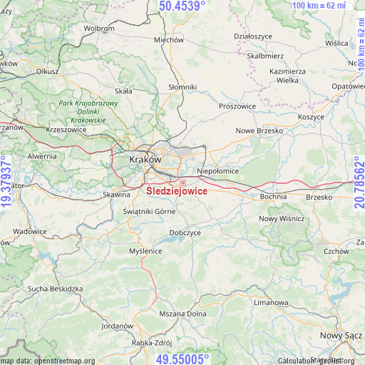
Śledziejowice GPS coordinates[2]
50° 0' 14.76" North, 20° 4' 56.964" East
| Map corner | latitude | longitude |
|---|---|---|
| Upper-left | 50.4539°, | 19.37937° |
| Center: | 50.0041°, | 20.08249° |
| Lower-right: | 49.55005°, | 20.78562° |
| Map W x H: | 100.5×100.5 km | = 62.4×62.4mi |
| max Lat: | 54.83135° ⇑82.3% North |
| Śledziejowice: | 50.0041° |
| min Lat: | ⇓17.7% South 49.21328° |
| min Long | Śledziejowice | max Long |
| 14.20249° | 20.08249° | 24.03723° |
| W 59.6%⇐ | ⇒40.4% E |
Elevation
Elevation of Śledziejowice is 225 m = 738 ft, and this is 33.6 m = 110 ft above average elevation for this country.
| Max E: |
974 m = 3196 ft | 31.3% |
| Śledziejowice | 225 m 738 ft | |
| Avg. | 191.4 m = 628 ft | |
Min E: |
-3 m = -10 ft | 68.7% |
See also: Poland elevation on elevation.city.
Geographical zone
Śledziejowice is located in North temperate zone (between Tropic of Cancer and the Arctic Circle). Distance of this North polar circle is 1841.2 km =1144.1 mi to North.| Distance of | km | miles | from Śledziejowice |
|---|---|---|---|
| North Pole | 4447.1 | 2763.3 | to North |
| Arctic Circle | 1841.2 | 1144.1 | to North |
| Tropic Cancer | 2954 | 1835.5 | to South |
| Equator | 5559.9 | 3454.8 | to South |


Nearby cities:
15 places around Śledziejowice: (largest is in red/bold)
• Biskupice
5.3 km =3.3 mi,  148°
148°
• Czarnochowice
1 km =0.6 mi,  273°
273°
• Kokotów
1 km =0.6 mi,  342°
342°
• Niepołomice
10.8 km =6.7 mi,  67°
67°
• Ochojno
9.6 km =6 mi,  233°
233°
• Pawlikowice
6 km =3.7 mi,  199°
199°
• Podłęże
6.2 km =3.9 mi,  79°
79°
• Rzeszotary
10.1 km =6.3 mi, 230°
• Szczytniki
11.1 km =6.9 mi,  107°
107°
• Tomaszkowice
3 km =1.9 mi,  156°
156°
• Trąbki
6.3 km =3.9 mi,  137°
137°
• Wieliczka
2.3 km =1.4 mi,  214°
214°
• Wrząsowice
11 km =6.8 mi,  242°
242°
• Węgrzce Wielkie
2.4 km =1.5 mi,  59°
59°
• Zabawa
1.2 km =0.7 mi, 148°
Sources, notices
• [Note1] Compared only with cities in Poland existing in our database
• [Src1] Map data: © OpenStreetMap contributors (CC-BY-SA)
• [Src2] Other city data from geonames.org with taken over terms of usage.
• [Src3] Geographical zone / Annual Mean Temperature by Robert A. Rohde @ Wikipedia
