Ustrzyki Dolne geodata
Ustrzyki Dolne (Subcarpathian) is a seat of a second-order administrative division; located in Poland in Europe/Warsaw (GMT+2) time zone. With population of 9,610 people, there are 458 cities with bigger population in this country. Compared to other cities in Poland, 99.3% of cities are located further ↑North; 92.7% of cities are located further ←West and 96.6% of cities have lower elevation than Ustrzyki Dolne. Note1
Administrative division(s):
- Level 1: Subcarpathian
- Level 2: Powiat bieszczadzki
- Level 3: Ustrzyki Dolne


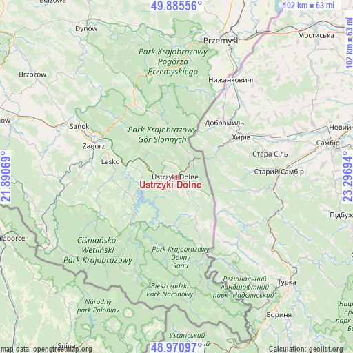
Ustrzyki Dolne GPS coordinates[2]
49° 25' 49.44" North, 22° 35' 37.716" East
| Map corner | latitude | longitude |
|---|---|---|
| Upper-left | 49.88556°, | 21.89069° |
| Center: | 49.4304°, | 22.59381° |
| Lower-right: | 48.97097°, | 23.29694° |
| Map W x H: | 101.7×101.7 km | = 63.2×63.2mi |
| max Lat: | 54.83135° ⇑99.3% North |
| Ustrzyki Dolne: | 49.4304° |
| min Lat: | ⇓0.7% South 49.21328° |
| min Long | Ustrzyki Dolne | max Long |
| 14.20249° | 22.59381° | 24.03723° |
| W 92.7%⇐ | ⇒7.3% E |
Elevation
Elevation of Ustrzyki Dolne is 462 m = 1516 ft, and this is 270.6 m = 888 ft above average elevation for this country.
| Max E: |
974 m = 3196 ft | 3.4% |
| Ustrzyki Dolne | 462 m 1516 ft | |
| Avg. | 191.4 m = 628 ft | |
Min E: |
-3 m = -10 ft | 96.6% |
See also: Poland elevation on elevation.city.
Geographical zone
Ustrzyki Dolne is located in North temperate zone (between Tropic of Cancer and the Arctic Circle). Distance of this North polar circle is 1905 km =1183.7 mi to North.| Distance of | km | miles | from Ustrzyki Dolne |
|---|---|---|---|
| North Pole | 4510.9 | 2802.9 | to North |
| Arctic Circle | 1905 | 1183.7 | to North |
| Tropic Cancer | 2890.2 | 1795.9 | to South |
| Equator | 5496.1 | 3415.1 | to South |


Nearby cities:
15 places around Ustrzyki Dolne: (largest is in red/bold)
• Baligród
24.9 km =15.5 mi,  243°
243°
• Czarna
12 km =7.5 mi,  156°
156°
• Czaszyn
27.4 km =17 mi,  274°
274°
• Krościenko
6.8 km =4.2 mi,  45°
45°
• Lesko
19.5 km =12.1 mi,  283°
283°
• Lutowiska
21 km =13 mi, 160°
• Myczkowce
13.3 km =8.3 mi, 273°
• Olszanica
12 km =7.5 mi,  295°
295°
• Polańczyk
14.2 km =8.8 mi, 241°
• Tarnawa Dolna
24.8 km =15.4 mi, 282°
• Tarnawa Górna
24.6 km =15.3 mi, 276°
• Tyrawa Wołoska
23 km =14.3 mi,  315°
315°
• Uherce Mineralne
14.6 km =9.1 mi,  285°
285°
• Zagórz
25.4 km =15.8 mi, 291°
• Łukowe
25.5 km =15.8 mi, 269°
Sources, notices
• [Note1] Compared only with cities in Poland existing in our database
• [Src1] Map data: © OpenStreetMap contributors (CC-BY-SA)
• [Src2] Other city data from geonames.org with taken over terms of usage.
• [Src3] Geographical zone / Annual Mean Temperature by Robert A. Rohde @ Wikipedia
