Lutowiska geodata
Lutowiska (Subcarpathian) is a seat of a third-order administrative division; located in Poland in Europe/Warsaw (GMT+2) time zone. With population of 750 people, there are 2953 cities with bigger population in this country. Compared to other cities in Poland, 100% of cities are located further ↑North; 93.8% of cities are located further ←West and 99.2% of cities have lower elevation than Lutowiska. Note1


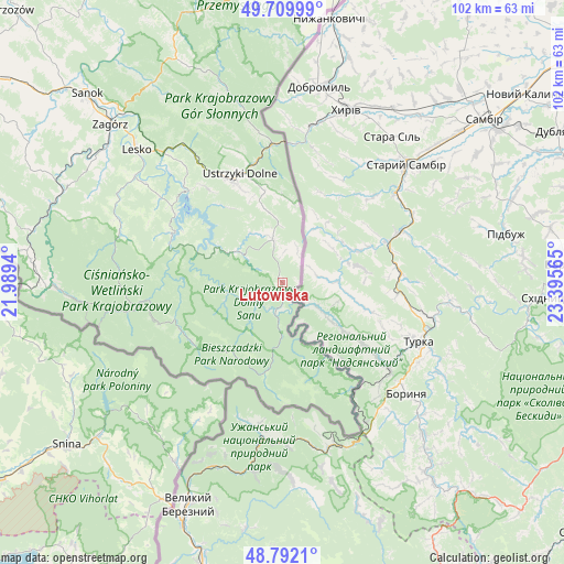
Lutowiska GPS coordinates[2]
49° 15' 11.448" North, 22° 41' 33.072" East
| Map corner | latitude | longitude |
|---|---|---|
| Upper-left | 49.70999°, | 21.9894° |
| Center: | 49.25318°, | 22.69252° |
| Lower-right: | 48.7921°, | 23.39565° |
| Map W x H: | 102.1×102.1 km | = 63.4×63.4mi |
| max Lat: | 54.83135° ⇑100% North |
| Lutowiska: | 49.25318° |
| min Lat: | ⇓0% South 49.21328° |
| min Long | Lutowiska | max Long |
| 14.20249° | 22.69252° | 24.03723° |
| W 93.8%⇐ | ⇒6.2% E |
Elevation
Elevation of Lutowiska is 640 m = 2100 ft, and this is 448.6 m = 1472 ft above average elevation for this country.
| Max E: |
974 m = 3196 ft | 0.8% |
| Lutowiska | 640 m 2100 ft | |
| Avg. | 191.4 m = 628 ft | |
Min E: |
-3 m = -10 ft | 99.2% |
See also: Poland elevation on elevation.city.
Geographical zone
Lutowiska is located in North temperate zone (between Tropic of Cancer and the Arctic Circle). Distance of this North polar circle is 1924.7 km =1196 mi to North.| Distance of | km | miles | from Lutowiska |
|---|---|---|---|
| North Pole | 4530.6 | 2815.2 | to North |
| Arctic Circle | 1924.7 | 1196 | to North |
| Tropic Cancer | 2870.5 | 1783.6 | to South |
| Equator | 5476.4 | 3402.9 | to South |


Nearby cities:
15 places around Lutowiska: (largest is in red/bold)
• Baligród
30.7 km =19.1 mi,  286°
286°
• Cisna
26.8 km =16.7 mi,  260°
260°
• Czarna
9 km =5.6 mi,  344°
344°
• Czaszyn
40.8 km =25.4 mi,  302°
302°
• Krościenko
24.6 km =15.3 mi,  354°
354°
• Lesko
35.6 km =22.1 mi,  312°
312°
• Myczkowce
29 km =18 mi,  315°
315°
• Olszanica
30.8 km =19.1 mi, 324°
• Polańczyk
23.6 km =14.7 mi, 303°
• Tarnawa Dolna
40.1 km =24.9 mi, 308°
• Tarnawa Górna
38.9 km =24.2 mi, 305°
• Uherce Mineralne
31.7 km =19.7 mi, 317°
• Ustrzyki Dolne
21 km =13 mi, 340°
• Zagórz
42.3 km =26.3 mi, 313°
• Łukowe
38 km =23.6 mi, 300°
Sources, notices
• [Note1] Compared only with cities in Poland existing in our database
• [Src1] Map data: © OpenStreetMap contributors (CC-BY-SA)
• [Src2] Other city data from geonames.org with taken over terms of usage.
• [Src3] Geographical zone / Annual Mean Temperature by Robert A. Rohde @ Wikipedia
