Krościenko geodata
Krościenko (Subcarpathian) is a populated place; located in Poland in Europe/Warsaw (GMT+2) time zone. With population of 590 people, there are 3306 cities with bigger population in this country. Compared to other cities in Poland, 98.8% of cities are located further ↑North; 93.5% of cities are located further ←West and 94.5% of cities have lower elevation than Krościenko. Note1
Administrative division(s):
- Level 1: Subcarpathian
- Level 2: Powiat bieszczadzki
- Level 3: Ustrzyki Dolne


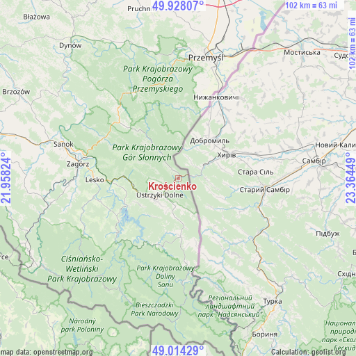
Krościenko GPS coordinates[2]
49° 28' 23.916" North, 22° 39' 40.896" East
| Map corner | latitude | longitude |
|---|---|---|
| Upper-left | 49.92807°, | 21.95824° |
| Center: | 49.47331°, | 22.66136° |
| Lower-right: | 49.01429°, | 23.36449° |
| Map W x H: | 101.6×101.6 km | = 63.1×63.1mi |
| max Lat: | 54.83135° ⇑98.8% North |
| Krościenko: | 49.47331° |
| min Lat: | ⇓1.2% South 49.21328° |
| min Long | Krościenko | max Long |
| 14.20249° | 22.66136° | 24.03723° |
| W 93.5%⇐ | ⇒6.5% E |
Elevation
Elevation of Krościenko is 405 m = 1329 ft, and this is 213.6 m = 701 ft above average elevation for this country.
| Max E: |
974 m = 3196 ft | 5.5% |
| Krościenko | 405 m 1329 ft | |
| Avg. | 191.4 m = 628 ft | |
Min E: |
-3 m = -10 ft | 94.5% |
See also: Poland elevation on elevation.city.
Geographical zone
Krościenko is located in North temperate zone (between Tropic of Cancer and the Arctic Circle). Distance of this North polar circle is 1900.3 km =1180.8 mi to North.| Distance of | km | miles | from Krościenko |
|---|---|---|---|
| North Pole | 4506.1 | 2800 | to North |
| Arctic Circle | 1900.3 | 1180.8 | to North |
| Tropic Cancer | 2895 | 1798.9 | to South |
| Equator | 5500.9 | 3418.1 | to South |


Nearby cities:
15 places around Krościenko: (largest is in red/bold)
• Bircza
27.6 km =17.1 mi,  331°
331°
• Czarna
15.8 km =9.8 mi,  180°
180°
• Fredropol
25.5 km =15.8 mi,  13°
13°
• Lesko
23.9 km =14.9 mi,  269°
269°
• Lutowiska
24.6 km =15.3 mi,  174°
174°
• Myczkowce
18.6 km =11.6 mi,  257°
257°
• Olszanica
15.7 km =9.8 mi, 271°
• Polańczyk
20.8 km =12.9 mi,  236°
236°
• Tarnawa Dolna
29.1 km =18.1 mi, 270°
• Tarnawa Górna
29.3 km =18.2 mi, 266°
• Tyrawa Wołoska
24 km =14.9 mi,  298°
298°
• Uherce Mineralne
19 km =11.8 mi, 267°
• Ustrzyki Dolne
6.8 km =4.2 mi,  225°
225°
• Zagórz
28.8 km =17.9 mi,  279°
279°
• Łukowe
30.8 km =19.1 mi, 260°
Sources, notices
• [Note1] Compared only with cities in Poland existing in our database
• [Src1] Map data: © OpenStreetMap contributors (CC-BY-SA)
• [Src2] Other city data from geonames.org with taken over terms of usage.
• [Src3] Geographical zone / Annual Mean Temperature by Robert A. Rohde @ Wikipedia
