Czarna geodata
Czarna (Subcarpathian) is a seat of a third-order administrative division; located in Poland in Europe/Warsaw (GMT+2) time zone. With population of 792 people, there are 2872 cities with bigger population in this country. Compared to other cities in Poland, 99.9% of cities are located further ↑North; 93.4% of cities are located further ←West and 98.2% of cities have lower elevation than Czarna. Note1


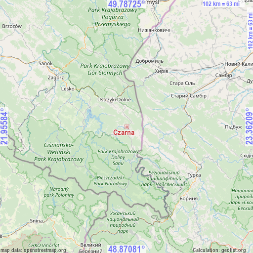
Czarna GPS coordinates[2]
49° 19' 52.176" North, 22° 39' 32.256" East
| Map corner | latitude | longitude |
|---|---|---|
| Upper-left | 49.78725°, | 21.95584° |
| Center: | 49.33116°, | 22.65896° |
| Lower-right: | 48.87081°, | 23.36209° |
| Map W x H: | 101.9×101.9 km | = 63.3×63.3mi |
| max Lat: | 54.83135° ⇑99.9% North |
| Czarna: | 49.33116° |
| min Lat: | ⇓0.1% South 49.21328° |
| min Long | Czarna | max Long |
| 14.20249° | 22.65896° | 24.03723° |
| W 93.4%⇐ | ⇒6.6% E |
Elevation
Elevation of Czarna is 560 m = 1837 ft, and this is 368.6 m = 1209 ft above average elevation for this country.
| Max E: |
974 m = 3196 ft | 1.8% |
| Czarna | 560 m 1837 ft | |
| Avg. | 191.4 m = 628 ft | |
Min E: |
-3 m = -10 ft | 98.2% |
See also: Poland elevation on elevation.city.
Geographical zone
Czarna is located in North temperate zone (between Tropic of Cancer and the Arctic Circle). Distance of this North polar circle is 1916.1 km =1190.6 mi to North.| Distance of | km | miles | from Czarna |
|---|---|---|---|
| North Pole | 4522 | 2809.8 | to North |
| Arctic Circle | 1916.1 | 1190.6 | to North |
| Tropic Cancer | 2879.2 | 1789.1 | to South |
| Equator | 5485.1 | 3408.3 | to South |


Nearby cities:
15 places around Czarna: (largest is in red/bold)
• Baligród
27 km =16.8 mi,  269°
269°
• Cisna
27.4 km =17 mi,  241°
241°
• Czaszyn
34.6 km =21.5 mi,  292°
292°
• Krościenko
15.8 km =9.8 mi,  0°
0°
• Lesko
28.4 km =17.6 mi,  303°
303°
• Lutowiska
9 km =5.6 mi,  164°
164°
• Myczkowce
21.6 km =13.4 mi, 303°
• Olszanica
22.5 km =14 mi,  316°
316°
• Polańczyk
17.8 km =11.1 mi,  283°
283°
• Tarnawa Dolna
33.2 km =20.6 mi, 299°
• Tarnawa Górna
32.4 km =20.1 mi, 295°
• Tyrawa Wołoska
34.4 km =21.4 mi, 322°
• Uherce Mineralne
24 km =14.9 mi,  308°
308°
• Ustrzyki Dolne
12 km =7.5 mi,  336°
336°
• Łukowe
32.1 km =19.9 mi, 289°
Sources, notices
• [Note1] Compared only with cities in Poland existing in our database
• [Src1] Map data: © OpenStreetMap contributors (CC-BY-SA)
• [Src2] Other city data from geonames.org with taken over terms of usage.
• [Src3] Geographical zone / Annual Mean Temperature by Robert A. Rohde @ Wikipedia
