Trzciana geodata
Trzciana (Lesser Poland) is a populated place; located in Poland in Europe/Warsaw (GMT+2) time zone. With population of 1,462 people, there are 1905 cities with bigger population in this country. Compared to other cities in Poland, 90% of cities are located further ↑North; 63.4% of cities are located further ←West and 77.2% of cities have lower elevation than Trzciana. Note1


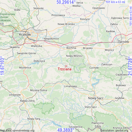
Trzciana GPS coordinates[2]
49° 50' 41.46" North, 20° 22' 26.94" East
| Map corner | latitude | longitude |
|---|---|---|
| Upper-left | 50.29614°, | 19.67103° |
| Center: | 49.84485°, | 20.37415° |
| Lower-right: | 49.3893°, | 21.07728° |
| Map W x H: | 100.8×100.8 km | = 62.6×62.6mi |
| max Lat: | 54.83135° ⇑90% North |
| Trzciana: | 49.84485° |
| min Lat: | ⇓10% South 49.21328° |
| min Long | Trzciana | max Long |
| 14.20249° | 20.37415° | 24.03723° |
| W 63.4%⇐ | ⇒36.6% E |
Elevation
Elevation of Trzciana is 255 m = 837 ft, and this is 63.6 m = 209 ft above average elevation for this country.
| Max E: |
974 m = 3196 ft | 22.8% |
| Trzciana | 255 m 837 ft | |
| Avg. | 191.4 m = 628 ft | |
Min E: |
-3 m = -10 ft | 77.2% |
See also: Poland elevation on elevation.city.
Geographical zone
Trzciana is located in North temperate zone (between Tropic of Cancer and the Arctic Circle). Distance of this North polar circle is 1858.9 km =1155.1 mi to North.| Distance of | km | miles | from Trzciana |
|---|---|---|---|
| North Pole | 4464.8 | 2774.3 | to North |
| Arctic Circle | 1858.9 | 1155.1 | to North |
| Tropic Cancer | 2936.3 | 1824.5 | to South |
| Equator | 5542.2 | 3443.8 | to South |


Nearby cities:
15 places around Trzciana: (largest is in red/bold)
• Gierczyce
11.8 km =7.3 mi,  349°
349°
• Jodłownik
12.6 km =7.8 mi,  231°
231°
• Krasne-Lasocice
11 km =6.8 mi,  250°
250°
• Książnice
13 km =8.1 mi,  334°
334°
• Laskowa
10.8 km =6.7 mi,  149°
149°
• Lipnica Murowana
11 km =6.8 mi,  81°
81°
• Marszowice
12.7 km =7.9 mi,  309°
309°
• Nowy Wiśnicz
10 km =6.2 mi,  38°
38°
• Pierzchów
12 km =7.5 mi, 326°
• Siedlec
12.8 km =8 mi,  342°
342°
• Stary Wiśnicz
12 km =7.5 mi, 41°
• Zręczyce
12.1 km =7.5 mi,  292°
292°
• Łapanów
6.4 km =4 mi, 291°
• Łapczyca
12.8 km =8 mi,  3°
3°
• Żegocina
4.7 km =2.9 mi,  136°
136°
Sources, notices
• [Note1] Compared only with cities in Poland existing in our database
• [Src1] Map data: © OpenStreetMap contributors (CC-BY-SA)
• [Src2] Other city data from geonames.org with taken over terms of usage.
• [Src3] Geographical zone / Annual Mean Temperature by Robert A. Rohde @ Wikipedia
