Łapanów geodata
Łapanów (Lesser Poland) is a seat of a third-order administrative division; located in Poland in Europe/Warsaw (GMT+2) time zone. With population of 1,000 people, there are 2459 cities with bigger population in this country. Compared to other cities in Poland, 89.1% of cities are located further ↑North; 62.4% of cities are located further ←West and 70.9% of cities have lower elevation than Łapanów. Note1


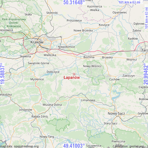
Łapanów GPS coordinates[2]
49° 51' 55.368" North, 20° 17' 29.364" East
| Map corner | latitude | longitude |
|---|---|---|
| Upper-left | 50.31648°, | 19.58837° |
| Center: | 49.86538°, | 20.29149° |
| Lower-right: | 49.41003°, | 20.99462° |
| Map W x H: | 100.8×100.8 km | = 62.6×62.6mi |
| max Lat: | 54.83135° ⇑89.1% North |
| Łapanów: | 49.86538° |
| min Lat: | ⇓10.9% South 49.21328° |
| min Long | Łapanów | max Long |
| 14.20249° | 20.29149° | 24.03723° |
| W 62.4%⇐ | ⇒37.6% E |
Elevation
Elevation of Łapanów is 232 m = 761 ft, and this is 40.6 m = 133 ft above average elevation for this country.
| Max E: |
974 m = 3196 ft | 29.1% |
| Łapanów | 232 m 761 ft | |
| Avg. | 191.4 m = 628 ft | |
Min E: |
-3 m = -10 ft | 70.9% |
See also: Poland elevation on elevation.city.
Geographical zone
Łapanów is located in North temperate zone (between Tropic of Cancer and the Arctic Circle). Distance of this North polar circle is 1856.7 km =1153.7 mi to North.| Distance of | km | miles | from Łapanów |
|---|---|---|---|
| North Pole | 4462.6 | 2772.9 | to North |
| Arctic Circle | 1856.7 | 1153.7 | to North |
| Tropic Cancer | 2938.6 | 1826 | to South |
| Equator | 5544.5 | 3445.2 | to South |


Nearby cities:
15 places around Łapanów: (largest is in red/bold)
• Cichawa
9.7 km =6 mi,  349°
349°
• Gdów
8.2 km =5.1 mi,  305°
305°
• Gierczyce
10.1 km =6.3 mi,  21°
21°
• Jodłownik
10.8 km =6.7 mi,  201°
201°
• Krasne-Lasocice
7.4 km =4.6 mi,  217°
217°
• Książnice
9.5 km =5.9 mi,  1°
1°
• Marszowice
7 km =4.3 mi,  325°
325°
• Pierzchów
7.8 km =4.8 mi, 354°
• Raciechowice
10.9 km =6.8 mi,  257°
257°
• Siedlec
10.1 km =6.3 mi,  11°
11°
• Szczytniki
12.9 km =8 mi,  340°
340°
• Trzciana
6.4 km =4 mi,  111°
111°
• Zręczyce
5.8 km =3.6 mi,  294°
294°
• Łapczyca
12.4 km =7.7 mi,  32°
32°
• Żegocina
10.8 km =6.7 mi,  121°
121°
Sources, notices
• [Note1] Compared only with cities in Poland existing in our database
• [Src1] Map data: © OpenStreetMap contributors (CC-BY-SA)
• [Src2] Other city data from geonames.org with taken over terms of usage.
• [Src3] Geographical zone / Annual Mean Temperature by Robert A. Rohde @ Wikipedia
