Krasne-Lasocice geodata
Krasne-Lasocice (Lesser Poland) is a populated place; located in Poland in Europe/Warsaw (GMT+2) time zone. With population of 640 people, there are 3187 cities with bigger population in this country. Compared to other cities in Poland, 91.3% of cities are located further ↑North; 61.5% of cities are located further ←West and 92.7% of cities have lower elevation than Krasne-Lasocice. Note1


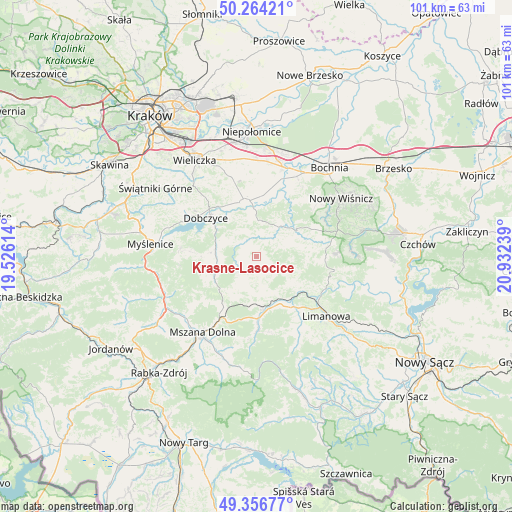
Krasne-Lasocice GPS coordinates[2]
49° 48' 45.432" North, 20° 13' 45.336" East
| Map corner | latitude | longitude |
|---|---|---|
| Upper-left | 50.26421°, | 19.52614° |
| Center: | 49.81262°, | 20.22926° |
| Lower-right: | 49.35677°, | 20.93239° |
| Map W x H: | 100.9×100.9 km | = 62.7×62.7mi |
| max Lat: | 54.83135° ⇑91.3% North |
| Krasne-Lasocice: | 49.81262° |
| min Lat: | ⇓8.7% South 49.21328° |
| min Long | Krasne-Lasocice | max Long |
| 14.20249° | 20.22926° | 24.03723° |
| W 61.5%⇐ | ⇒38.5% E |
Elevation
Elevation of Krasne-Lasocice is 365 m = 1198 ft, and this is 173.6 m = 570 ft above average elevation for this country.
| Max E: |
974 m = 3196 ft | 7.3% |
| Krasne-Lasocice | 365 m 1198 ft | |
| Avg. | 191.4 m = 628 ft | |
Min E: |
-3 m = -10 ft | 92.7% |
See also: Poland elevation on elevation.city.
Geographical zone
Krasne-Lasocice is located in North temperate zone (between Tropic of Cancer and the Arctic Circle). Distance of this North polar circle is 1862.5 km =1157.3 mi to North.| Distance of | km | miles | from Krasne-Lasocice |
|---|---|---|---|
| North Pole | 4468.4 | 2776.5 | to North |
| Arctic Circle | 1862.5 | 1157.3 | to North |
| Tropic Cancer | 2932.7 | 1822.3 | to South |
| Equator | 5538.6 | 3441.5 | to South |


Nearby cities:
15 places around Krasne-Lasocice: (largest is in red/bold)
• Dobczyce
12.6 km =7.8 mi,  307°
307°
• Dobra
10.7 km =6.6 mi,  170°
170°
• Gdów
10.8 km =6.7 mi,  348°
348°
• Jodłownik
4.2 km =2.6 mi, 172°
• Kasina Wielka
11.4 km =7.1 mi,  216°
216°
• Kornatka
11.2 km =7 mi,  292°
292°
• Lipnik
10.7 km =6.6 mi,  255°
255°
• Marszowice
11.7 km =7.3 mi,  2°
2°
• Raciechowice
7.1 km =4.4 mi,  299°
299°
• Skrzydlna
7.3 km =4.5 mi,  205°
205°
• Trzciana
11 km =6.8 mi,  70°
70°
• Tymbark
11.6 km =7.2 mi,  143°
143°
• Wiśniowa
8.7 km =5.4 mi,  251°
251°
• Zręczyce
8.3 km =5.2 mi, 354°
• Łapanów
7.4 km =4.6 mi,  37°
37°
Sources, notices
• [Note1] Compared only with cities in Poland existing in our database
• [Src1] Map data: © OpenStreetMap contributors (CC-BY-SA)
• [Src2] Other city data from geonames.org with taken over terms of usage.
• [Src3] Geographical zone / Annual Mean Temperature by Robert A. Rohde @ Wikipedia
