Jodłownik geodata
Jodłownik (Lesser Poland) is a populated place; located in Poland in Europe/Warsaw (GMT+2) time zone. With population of 971 people, there are 2549 cities with bigger population in this country. Compared to other cities in Poland, 92.6% of cities are located further ↑North; 61.6% of cities are located further ←West and 89.8% of cities have lower elevation than Jodłownik. Note1


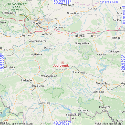
Jodłownik GPS coordinates[2]
49° 46' 30.612" North, 20° 14' 11.292" East
| Map corner | latitude | longitude |
|---|---|---|
| Upper-left | 50.22711°, | 19.53335° |
| Center: | 49.77517°, | 20.23647° |
| Lower-right: | 49.31897°, | 20.9396° |
| Map W x H: | 101×101 km | = 62.8×62.8mi |
| max Lat: | 54.83135° ⇑92.6% North |
| Jodłownik: | 49.77517° |
| min Lat: | ⇓7.4% South 49.21328° |
| min Long | Jodłownik | max Long |
| 14.20249° | 20.23647° | 24.03723° |
| W 61.6%⇐ | ⇒38.4% E |
Elevation
Elevation of Jodłownik is 324 m = 1063 ft, and this is 132.6 m = 435 ft above average elevation for this country.
| Max E: |
974 m = 3196 ft | 10.2% |
| Jodłownik | 324 m 1063 ft | |
| Avg. | 191.4 m = 628 ft | |
Min E: |
-3 m = -10 ft | 89.8% |
See also: Poland elevation on elevation.city.
Geographical zone
Jodłownik is located in North temperate zone (between Tropic of Cancer and the Arctic Circle). Distance of this North polar circle is 1866.7 km =1159.9 mi to North.| Distance of | km | miles | from Jodłownik |
|---|---|---|---|
| North Pole | 4472.6 | 2779.1 | to North |
| Arctic Circle | 1866.7 | 1159.9 | to North |
| Tropic Cancer | 2928.6 | 1819.7 | to South |
| Equator | 5534.5 | 3439 | to South |


Nearby cities:
15 places around Jodłownik: (largest is in red/bold)
• Dobra
6.5 km =4 mi,  169°
169°
• Kasina Wielka
8.8 km =5.5 mi,  235°
235°
• Krasne-Lasocice
4.2 km =2.6 mi,  352°
352°
• Lipnik
11 km =6.8 mi,  278°
278°
• Raciechowice
10.2 km =6.3 mi,  318°
318°
• Skrzydlna
4.3 km =2.7 mi, 236°
• Słopnice
12.6 km =7.8 mi,  142°
142°
• Trzciana
12.6 km =7.8 mi,  51°
51°
• Tymbark
8.2 km =5.1 mi,  129°
129°
• Wilczyce
12.3 km =7.6 mi,  191°
191°
• Wiśniowa
8.8 km =5.5 mi, 279°
• Węglówka
11.7 km =7.3 mi,  247°
247°
• Zręczyce
12.5 km =7.8 mi, 353°
• Łapanów
10.8 km =6.7 mi,  21°
21°
• Żegocina
13.8 km =8.6 mi,  71°
71°
Sources, notices
• [Note1] Compared only with cities in Poland existing in our database
• [Src1] Map data: © OpenStreetMap contributors (CC-BY-SA)
• [Src2] Other city data from geonames.org with taken over terms of usage.
• [Src3] Geographical zone / Annual Mean Temperature by Robert A. Rohde @ Wikipedia
