Truskaw geodata
Truskaw (Mazovia) is a populated place; located in Poland in Europe/Warsaw (GMT+2) time zone. With population of 1,440 people, there are 1919 cities with bigger population in this country. Compared to other cities in Poland, 72.4% of cities are located further ↓South; 68.9% of cities are located further ←West and 88.4% of cities have higher elevation than Truskaw. Note1


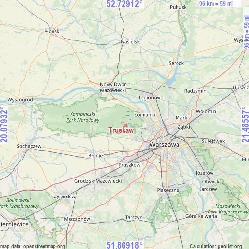
Truskaw GPS coordinates[2]
52° 18' 4.464" North, 20° 46' 56.784" East
| Map corner | latitude | longitude |
|---|---|---|
| Upper-left | 52.72912°, | 20.07932° |
| Center: | 52.30124°, | 20.78244° |
| Lower-right: | 51.86918°, | 21.48557° |
| Map W x H: | 95.6×95.6 km | = 59.4×59.4mi |
| max Lat: | 54.83135° ⇑27.6% North |
| Truskaw: | 52.30124° |
| min Lat: | ⇓72.4% South 49.21328° |
| min Long | Truskaw | max Long |
| 14.20249° | 20.78244° | 24.03723° |
| W 68.9%⇐ | ⇒31.1% E |
Elevation
Elevation of Truskaw is 80 m = 262 ft, and this is 111.4 m = 365 ft below average elevation for this country.
| Max E: |
974 m = 3196 ft | 88.4% |
| Avg. | 191.4 m = 628 ft | |
| Truskaw | 80 m = 262 ft | |
Min E: |
-3 m = -10 ft | 11.6% |
See also: Poland elevation on elevation.city.
Geographical zone
Truskaw is located in North temperate zone (between Tropic of Cancer and the Arctic Circle). Distance of this North polar circle is 1585.8 km =985.4 mi to North.| Distance of | km | miles | from Truskaw |
|---|---|---|---|
| North Pole | 4191.7 | 2604.6 | to North |
| Arctic Circle | 1585.8 | 985.4 | to North |
| Tropic Cancer | 3209.4 | 1994.2 | to South |
| Equator | 5815.4 | 3613.5 | to South |


Nearby cities:
15 places around Truskaw: (largest is in red/bold)
• Babice
7.3 km =4.5 mi,  140°
140°
• Bemowo
10 km =6.2 mi,  121°
121°
• Bielany
10.4 km =6.5 mi,  95°
95°
• Dziekanów Bajkowy
7.9 km =4.9 mi,  36°
36°
• Dziekanów Leśny
7.4 km =4.6 mi, 39°
• Hornówek
2.4 km =1.5 mi,  133°
133°
• Izabelin
2.4 km =1.5 mi,  93°
93°
• Kiełpin
8.3 km =5.2 mi, 40°
• Ołtarzew
10.1 km =6.3 mi,  189°
189°
• Ożarów Mazowiecki
10.2 km =6.3 mi,  174°
174°
• Stare Babice
5.7 km =3.5 mi, 142°
• Zaborów
8.4 km =5.2 mi,  238°
238°
• Zielonki-Wieś
5.6 km =3.5 mi,  163°
163°
• Łomianki
7.9 km =4.9 mi,  62°
62°
• Łomna
9 km =5.6 mi,  358°
358°
Sources, notices
• [Note1] Compared only with cities in Poland existing in our database
• [Src1] Map data: © OpenStreetMap contributors (CC-BY-SA)
• [Src2] Other city data from geonames.org with taken over terms of usage.
• [Src3] Geographical zone / Annual Mean Temperature by Robert A. Rohde @ Wikipedia
