Ołtarzew geodata
Ołtarzew (Mazovia) is a populated place; located in Poland in Europe/Warsaw (GMT+2) time zone. With population of 524 people, there are 3472 cities with bigger population in this country. Compared to other cities in Poland, 70.5% of cities are located further ↓South; 68.5% of cities are located further ←West and 83.2% of cities have higher elevation than Ołtarzew. Note1
Administrative division(s):
- Level 1: Mazovia
- Level 2: Powiat warszawski zachodni
- Level 3: Ożarów Mazowiecki


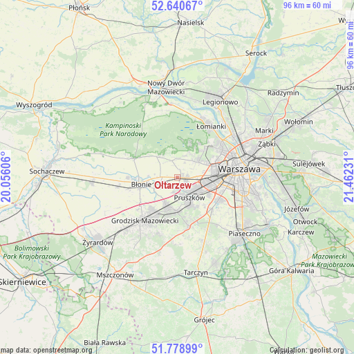
Ołtarzew GPS coordinates[2]
52° 12' 42.912" North, 20° 45' 33.048" East
| Map corner | latitude | longitude |
|---|---|---|
| Upper-left | 52.64067°, | 20.05606° |
| Center: | 52.21192°, | 20.75918° |
| Lower-right: | 51.77899°, | 21.46231° |
| Map W x H: | 95.8×95.8 km | = 59.5×59.5mi |
| max Lat: | 54.83135° ⇑29.5% North |
| Ołtarzew: | 52.21192° |
| min Lat: | ⇓70.5% South 49.21328° |
| min Long | Ołtarzew | max Long |
| 14.20249° | 20.75918° | 24.03723° |
| W 68.5%⇐ | ⇒31.5% E |
Elevation
Elevation of Ołtarzew is 93 m = 305 ft, and this is 98.4 m = 323 ft below average elevation for this country.
| Max E: |
974 m = 3196 ft | 83.2% |
| Avg. | 191.4 m = 628 ft | |
| Ołtarzew | 93 m = 305 ft | |
Min E: |
-3 m = -10 ft | 16.8% |
See also: Poland elevation on elevation.city.
Geographical zone
Ołtarzew is located in North temperate zone (between Tropic of Cancer and the Arctic Circle). Distance of this North polar circle is 1595.8 km =991.6 mi to North.| Distance of | km | miles | from Ołtarzew |
|---|---|---|---|
| North Pole | 4201.6 | 2610.8 | to North |
| Arctic Circle | 1595.8 | 991.6 | to North |
| Tropic Cancer | 3199.5 | 1988.1 | to South |
| Equator | 5805.4 | 3607.3 | to South |


Nearby cities:
15 places around Ołtarzew: (largest is in red/bold)
• Babice
7.5 km =4.7 mi,  55°
55°
• Brwinów
8.2 km =5.1 mi,  200°
200°
• Duchnice
2.9 km =1.8 mi,  112°
112°
• Hornówek
8.9 km =5.5 mi,  21°
21°
• Józefów
4.7 km =2.9 mi,  245°
245°
• Kanie
8.2 km =5.1 mi,  175°
175°
• Komorów
8.3 km =5.2 mi,  152°
152°
• Ożarów Mazowiecki
2.6 km =1.6 mi,  93°
93°
• Piastów
6.3 km =3.9 mi,  119°
119°
• Pruszków
5.8 km =3.6 mi,  141°
141°
• Reguły
8.2 km =5.1 mi, 119°
• Stare Babice
7.4 km =4.6 mi,  43°
43°
• Ursus
8.7 km =5.4 mi,  102°
102°
• Zaborów
7.9 km =4.9 mi,  315°
315°
• Zielonki-Wieś
5.6 km =3.5 mi,  34°
34°
Sources, notices
• [Note1] Compared only with cities in Poland existing in our database
• [Src1] Map data: © OpenStreetMap contributors (CC-BY-SA)
• [Src2] Other city data from geonames.org with taken over terms of usage.
• [Src3] Geographical zone / Annual Mean Temperature by Robert A. Rohde @ Wikipedia
