Ożarów Mazowiecki geodata
Ożarów Mazowiecki (Mazovia) is a seat of a second-order administrative division; located in Poland in Europe/Warsaw (GMT+2) time zone. With population of 8,237 people, there are 500 cities with bigger population in this country. Compared to other cities in Poland, 70.4% of cities are located further ↓South; 69% of cities are located further ←West and 80.6% of cities have higher elevation than Ożarów Mazowiecki. Note1
Administrative division(s):
- Level 1: Mazovia
- Level 2: Powiat warszawski zachodni
- Level 3: Ożarów Mazowiecki


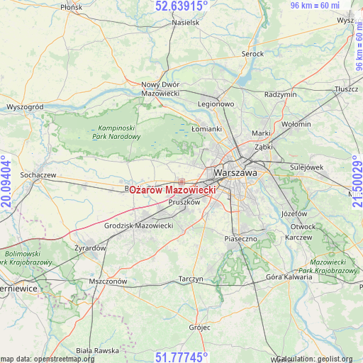
Ożarów Mazowiecki GPS coordinates[2]
52° 12' 37.404" North, 20° 47' 49.776" East
| Map corner | latitude | longitude |
|---|---|---|
| Upper-left | 52.63915°, | 20.09404° |
| Center: | 52.21039°, | 20.79716° |
| Lower-right: | 51.77745°, | 21.50029° |
| Map W x H: | 95.8×95.8 km | = 59.5×59.5mi |
| max Lat: | 54.83135° ⇑29.6% North |
| Ożarów Mazowiecki: | 52.21039° |
| min Lat: | ⇓70.4% South 49.21328° |
| min Long | Ożarów Mazowi | max Long |
| 14.20249° | 20.79716° | 24.03723° |
| W 69%⇐ | ⇒31% E |
Elevation
Elevation of Ożarów Mazowiecki is 98 m = 322 ft, and this is 93.4 m = 306 ft below average elevation for this country.
| Max E: |
974 m = 3196 ft | 80.6% |
| Avg. | 191.4 m = 628 ft | |
| Ożarów Mazowiecki | 98 m = 322 ft | |
Min E: |
-3 m = -10 ft | 19.4% |
See also: Poland elevation on elevation.city.
Geographical zone
Ożarów Mazowiecki is located in North temperate zone (between Tropic of Cancer and the Arctic Circle). Distance of this North polar circle is 1595.9 km =991.6 mi to North.| Distance of | km | miles | from Ożarów Mazowiecki |
|---|---|---|---|
| North Pole | 4201.8 | 2610.9 | to North |
| Arctic Circle | 1595.9 | 991.6 | to North |
| Tropic Cancer | 3199.3 | 1988 | to South |
| Equator | 5805.3 | 3607.2 | to South |


Nearby cities:
15 places around Ożarów Mazowiecki: (largest is in red/bold)
• Babice
5.7 km =3.5 mi,  39°
39°
• Duchnice
1 km =0.6 mi,  172°
172°
• Granica
8.5 km =5.3 mi,  177°
177°
• Hornówek
8.5 km =5.3 mi,  4°
4°
• Józefów
7.1 km =4.4 mi,  255°
255°
• Kanie
8.2 km =5.1 mi,  193°
193°
• Komorów
7.3 km =4.5 mi, 170°
• Michałowice
7 km =4.3 mi,  125°
125°
• Ołtarzew
2.6 km =1.6 mi,  273°
273°
• Piastów
4.1 km =2.5 mi,  135°
135°
• Pruszków
4.5 km =2.8 mi, 166°
• Reguły
6 km =3.7 mi, 130°
• Stare Babice
6.1 km =3.8 mi,  24°
24°
• Ursus
6.2 km =3.9 mi,  105°
105°
• Zielonki-Wieś
4.8 km =3 mi,  7°
7°
Sources, notices
• [Note1] Compared only with cities in Poland existing in our database
• [Src1] Map data: © OpenStreetMap contributors (CC-BY-SA)
• [Src2] Other city data from geonames.org with taken over terms of usage.
• [Src3] Geographical zone / Annual Mean Temperature by Robert A. Rohde @ Wikipedia
