Zaborów geodata
Zaborów (Mazovia) is a populated place; located in Poland in Europe/Warsaw (GMT+2) time zone. With population of 735 people, there are 2997 cities with bigger population in this country. Compared to other cities in Poland, 71.8% of cities are located further ↓South; 67.2% of cities are located further ←West and 84.6% of cities have higher elevation than Zaborów. Note1


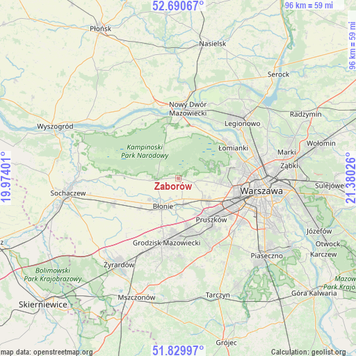
Zaborów GPS coordinates[2]
52° 15' 44.676" North, 20° 40' 37.668" East
| Map corner | latitude | longitude |
|---|---|---|
| Upper-left | 52.69067°, | 19.97401° |
| Center: | 52.26241°, | 20.67713° |
| Lower-right: | 51.82997°, | 21.38026° |
| Map W x H: | 95.7×95.7 km | = 59.5×59.5mi |
| max Lat: | 54.83135° ⇑28.2% North |
| Zaborów: | 52.26241° |
| min Lat: | ⇓71.8% South 49.21328° |
| min Long | Zaborów | max Long |
| 14.20249° | 20.67713° | 24.03723° |
| W 67.2%⇐ | ⇒32.8% E |
Elevation
Elevation of Zaborów is 90 m = 295 ft, and this is 101.4 m = 333 ft below average elevation for this country.
| Max E: |
974 m = 3196 ft | 84.6% |
| Avg. | 191.4 m = 628 ft | |
| Zaborów | 90 m = 295 ft | |
Min E: |
-3 m = -10 ft | 15.4% |
See also: Poland elevation on elevation.city.
Geographical zone
Zaborów is located in North temperate zone (between Tropic of Cancer and the Arctic Circle). Distance of this North polar circle is 1590.1 km =988 mi to North.| Distance of | km | miles | from Zaborów |
|---|---|---|---|
| North Pole | 4196 | 2607.3 | to North |
| Arctic Circle | 1590.1 | 988 | to North |
| Tropic Cancer | 3205.1 | 1991.6 | to South |
| Equator | 5811 | 3610.8 | to South |


Nearby cities:
15 places around Zaborów: (largest is in red/bold)
• Babice
11.9 km =7.4 mi,  96°
96°
• Bieniewice
11.8 km =7.3 mi,  221°
221°
• Boża Wola
13.4 km =8.3 mi,  230°
230°
• Brwinów
13.6 km =8.5 mi,  168°
168°
• Błonie
8.2 km =5.1 mi,  209°
209°
• Duchnice
10.7 km =6.6 mi,  129°
129°
• Hornówek
9.3 km =5.8 mi,  73°
73°
• Izabelin
10.4 km =6.5 mi, 66°
• Józefów
7.7 km =4.8 mi, 170°
• Leszno
5.9 km =3.7 mi,  265°
265°
• Ołtarzew
7.9 km =4.9 mi,  135°
135°
• Ożarów Mazowiecki
10 km =6.2 mi, 125°
• Stare Babice
10.7 km =6.6 mi,  91°
91°
• Truskaw
8.4 km =5.2 mi,  58°
58°
• Zielonki-Wieś
8.8 km =5.5 mi, 96°
Sources, notices
• [Note1] Compared only with cities in Poland existing in our database
• [Src1] Map data: © OpenStreetMap contributors (CC-BY-SA)
• [Src2] Other city data from geonames.org with taken over terms of usage.
• [Src3] Geographical zone / Annual Mean Temperature by Robert A. Rohde @ Wikipedia
