Babice geodata
Babice (Mazovia) is a seat of a fourth-order administrative division; located in Poland in Europe/Warsaw (GMT+2) time zone. In our database, there are 3649 cities with bigger population. Compared to other cities in Poland, 71.3% of cities are located further ↓South; 69.9% of cities are located further ←West and 79.3% of cities have higher elevation than Babice. Note1
Administrative division(s):
- Level 1: Mazovia
- Level 2: Powiat warszawski zachodni
- Level 3: Stare Babice


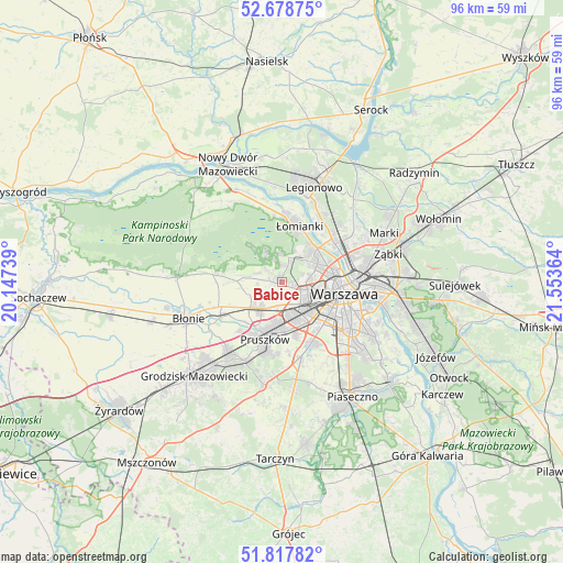
Babice GPS coordinates[2]
52° 15' 1.332" North, 20° 51' 1.836" East
| Map corner | latitude | longitude |
|---|---|---|
| Upper-left | 52.67875°, | 20.14739° |
| Center: | 52.25037°, | 20.85051° |
| Lower-right: | 51.81782°, | 21.55364° |
| Map W x H: | 95.7×95.7 km | = 59.5×59.5mi |
| max Lat: | 54.83135° ⇑28.7% North |
| Babice: | 52.25037° |
| min Lat: | ⇓71.3% South 49.21328° |
| min Long | Babice | max Long |
| 14.20249° | 20.85051° | 24.03723° |
| W 69.9%⇐ | ⇒30.1% E |
Elevation
Elevation of Babice is 101 m = 331 ft, and this is 90.4 m = 297 ft below average elevation for this country.
| Max E: |
974 m = 3196 ft | 79.3% |
| Avg. | 191.4 m = 628 ft | |
| Babice | 101 m = 331 ft | |
Min E: |
-3 m = -10 ft | 20.7% |
See also: Poland elevation on elevation.city.
Geographical zone
Babice is located in North temperate zone (between Tropic of Cancer and the Arctic Circle). Distance of this North polar circle is 1591.5 km =988.9 mi to North.| Distance of | km | miles | from Babice |
|---|---|---|---|
| North Pole | 4197.4 | 2608.1 | to North |
| Arctic Circle | 1591.5 | 988.9 | to North |
| Tropic Cancer | 3203.8 | 1990.7 | to South |
| Equator | 5809.7 | 3610 | to South |


Nearby cities:
15 places around Babice: (largest is in red/bold)
• Bemowo
4 km =2.5 mi,  83°
83°
• Bielany
7.4 km =4.6 mi,  50°
50°
• Duchnice
6.5 km =4 mi,  212°
212°
• Hornówek
4.9 km =3 mi,  324°
324°
• Izabelin
6 km =3.7 mi,  337°
337°
• Michałowice
8.7 km =5.4 mi,  166°
166°
• Ołtarzew
7.5 km =4.7 mi,  235°
235°
• Ożarów Mazowiecki
5.7 km =3.5 mi,  219°
219°
• Piastów
7.4 km =4.6 mi,  185°
185°
• Pruszków
9.2 km =5.7 mi,  196°
196°
• Reguły
8.4 km =5.2 mi, 173°
• Stare Babice
1.6 km =1 mi,  314°
314°
• Truskaw
7.3 km =4.5 mi, 320°
• Ursus
6.6 km =4.1 mi,  159°
159°
• Zielonki-Wieś
3 km =1.9 mi,  276°
276°
Sources, notices
• [Note1] Compared only with cities in Poland existing in our database
• [Src1] Map data: © OpenStreetMap contributors (CC-BY-SA)
• [Src2] Other city data from geonames.org with taken over terms of usage.
• [Src3] Geographical zone / Annual Mean Temperature by Robert A. Rohde @ Wikipedia
