Szaflary geodata
Szaflary (Lesser Poland) is a populated place; located in Poland in Europe/Warsaw (GMT+2) time zone. With population of 2,200 people, there are 1362 cities with bigger population in this country. Compared to other cities in Poland, 99.4% of cities are located further ↑North; 58.7% of cities are located further ←West and 99.1% of cities have lower elevation than Szaflary. Note1


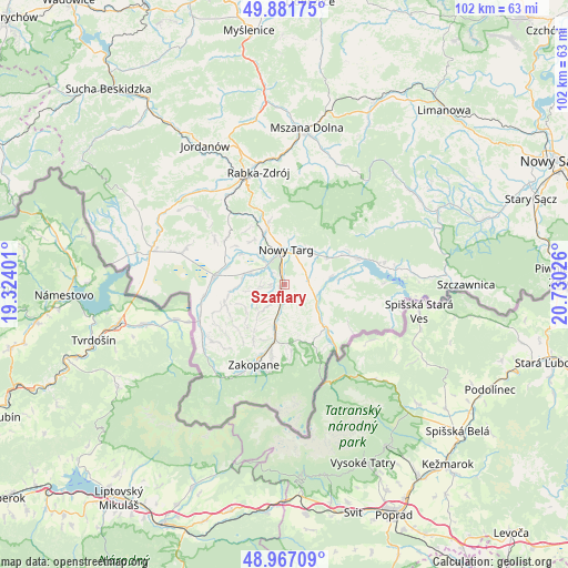
Szaflary GPS coordinates[2]
49° 25' 35.58" North, 20° 1' 37.668" East
| Map corner | latitude | longitude |
|---|---|---|
| Upper-left | 49.88175°, | 19.32401° |
| Center: | 49.42655°, | 20.02713° |
| Lower-right: | 48.96709°, | 20.73026° |
| Map W x H: | 101.7×101.7 km | = 63.2×63.2mi |
| max Lat: | 54.83135° ⇑99.4% North |
| Szaflary: | 49.42655° |
| min Lat: | ⇓0.6% South 49.21328° |
| min Long | Szaflary | max Long |
| 14.20249° | 20.02713° | 24.03723° |
| W 58.7%⇐ | ⇒41.3% E |
Elevation
Elevation of Szaflary is 638 m = 2093 ft, and this is 446.6 m = 1465 ft above average elevation for this country.
| Max E: |
974 m = 3196 ft | 0.90000000000001% |
| Szaflary | 638 m 2093 ft | |
| Avg. | 191.4 m = 628 ft | |
Min E: |
-3 m = -10 ft | 99.1% |
See also: Poland elevation on elevation.city.
Geographical zone
Szaflary is located in North temperate zone (between Tropic of Cancer and the Arctic Circle). Distance of this North polar circle is 1905.5 km =1184 mi to North.| Distance of | km | miles | from Szaflary |
|---|---|---|---|
| North Pole | 4511.3 | 2803.2 | to North |
| Arctic Circle | 1905.5 | 1184 | to North |
| Tropic Cancer | 2889.8 | 1795.6 | to South |
| Equator | 5495.7 | 3414.9 | to South |


Nearby cities:
15 places around Szaflary: (largest is in red/bold)
• Białka Tatrzańska
7 km =4.3 mi,  125°
125°
• Biały Dunajec
6 km =3.7 mi,  192°
192°
• Czarna Góra
9.3 km =5.8 mi, 126°
• Klikuszowa
10.8 km =6.7 mi,  343°
343°
• Krauszów
7.4 km =4.6 mi,  316°
316°
• Lasek
9.7 km =6 mi, 339°
• Leśnica
3.7 km =2.3 mi,  140°
140°
• Ludźmierz
5.5 km =3.4 mi, 324°
• Nowy Targ
5.7 km =3.5 mi,  3°
3°
• Ostrowsko
7.7 km =4.8 mi,  43°
43°
• Poronin
10 km =6.2 mi, 190°
• Trute
8.4 km =5.2 mi,  329°
329°
• Waksmund
7.1 km =4.4 mi,  29°
29°
• Wróblówka
10.5 km =6.5 mi,  287°
287°
• Łopuszna
9.1 km =5.7 mi,  55°
55°
Sources, notices
• [Note1] Compared only with cities in Poland existing in our database
• [Src1] Map data: © OpenStreetMap contributors (CC-BY-SA)
• [Src2] Other city data from geonames.org with taken over terms of usage.
• [Src3] Geographical zone / Annual Mean Temperature by Robert A. Rohde @ Wikipedia
